File:2013May27 new map of Ashgabat and Akhal 2.jpg
Jump to navigation
Jump to search

Size of this preview: 772 × 600 pixels. Other resolutions: 309 × 240 pixels | 618 × 480 pixels | 900 × 699 pixels.
Original file (900 × 699 pixels, file size: 114 KB, MIME type: image/jpeg)
Summary
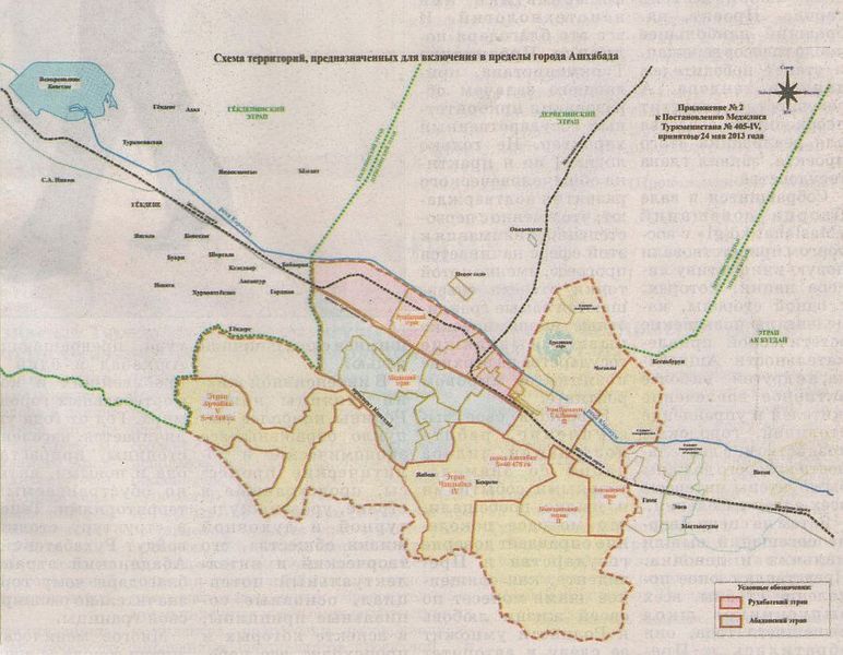
| Description | Historical map of Ashgabat and surrounding area of Ahal Province as of 27 May 2013, when parts of Ahal Province were annexed by the city. |
|---|---|
| Author | ?? |
| Source | ?? |
| Date | 2013-05-27 (?) |
Licensing
![]()
This file has been released into the public domain by the copyright holder, its copyright has expired, or it is ineligible for copyright. This applies worldwide.
Please, please use more specific template such as {{PD-self}} / {{PD-creator}} / {{PD-shape}} / {{PD-USGov}} / {{PD-old}} / {{PD-RU-exempt}} ... This template is not making clear why this work is in the public domain.
Please, please use more specific template such as {{PD-self}} / {{PD-creator}} / {{PD-shape}} / {{PD-USGov}} / {{PD-old}} / {{PD-RU-exempt}} ... This template is not making clear why this work is in the public domain.
File history
Click on a date/time to view the file as it appeared at that time.
| Date/Time | Thumbnail | Dimensions | User | Comment | |
|---|---|---|---|---|---|
| current | 11:58, 8 July 2018 | | 900 × 699 (114 KB) | Apm-wa (talk | contribs) | Historical map of Ashgabat and surrounding area of Ahal Province as of 27 May 2013, when parts of Ahal Province were annexed by the city. |
You cannot overwrite this file.
File usage
The following page uses this file: