File:Arzleralmlawine Anriss und Bremsbauten.jpg
Jump to navigation
Jump to search


Size of this preview: 800 × 600 pixels. Other resolutions: 320 × 240 pixels | 640 × 480 pixels | 1,024 × 768 pixels | 1,280 × 960 pixels | 1,664 × 1,248 pixels.
Original file (1,664 × 1,248 pixels, file size: 614 KB, MIME type: image/jpeg)
This file and its description are from Wikimedia Commons.
Summary
| Description |
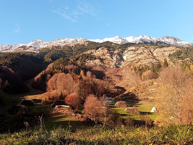
English: View of the upper track of Arzleralmlawine: On top slightly covered in snow the starting zone; track zone with retarding mounds in flat part and mostly hidden deflecting berms. Run out zone behind camera, ~250 m away, a basin and a dam. Camera pointing North.
Deutsch: Sicht auf den oberen Verlauf der Arzleralmlawine: Ganz oben leicht angezuckert die Anrisszone, im Verlauf der Lawinentrasse Bremshöcker am Flachstück und leicht versteckt Querdämme. Auslaufzone hinter der Kamera, ~250 m weiter, ein Becken und Auffangdamm. Ausrichtung der Kamera nach Norden. |
| Date | |
| Source | Own work |
| Author | Hungerburg |
| Camera location | | View this and other nearby images on: OpenStreetMap |
|---|
Licensing
I, the copyright holder of this work, hereby publish it under the following license:
This file is licensed under the Creative Commons Attribution-Share Alike 4.0 International license.
- You are free:
- to share – to copy, distribute and transmit the work
- to remix – to adapt the work
- Under the following conditions:
- attribution – You must give appropriate credit, provide a link to the license, and indicate if changes were made. You may do so in any reasonable manner, but not in any way that suggests the licensor endorses you or your use.
- share alike – If you remix, transform, or build upon the material, you must distribute your contributions under the same or compatible license as the original.
File history
Click on a date/time to view the file as it appeared at that time.
| Date/Time | Thumbnail | Dimensions | User | Comment | |
|---|---|---|---|---|---|
| current | 21:03, 28 December 2022 | | 1,664 × 1,248 (614 KB) | wikimediacommons>Hungerburg | Uploaded own work with UploadWizard |
File usage
The following page uses this file: