File:Autorização BHGeo.png

Original file (1,808 × 3,216 pixels, file size: 305 KB, MIME type: image/png)
Summary
English:
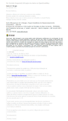
Capture of the e-mail sent by the BHGEO Portal (from PRODABEL – Informatics and Information Company of the Municipality of Belo Horizonte), where the use of their data is authorized on OpenStreetMap.
Message transcript and translated:
Karla A.V. Borges
Fri, 02/18/2022 15:15
Dear Matheus,
We changed the license because we thought the other one was more restrictive.
Therefore, you [OSM] can continue using the data.
This is our goal, that data can be used and shared.
Any questions please contact us.
Karla Albuquerque de V. Borges | Corporate Geoprocessing Superintendence - SGS-PB
Information Technology and Information Company of the Municipality of Belo Horizonte - PRODABEL
Ave Presidente Carlos Luz, 1° andar | sala 120 | Bairro Caiçaras | CEP 30.230-000 | BH/MG
(31) 32778335, www.pbh.gov.br
Forwarded message ---------
From: BH GEO <matheus.gomes03@hotmail.com>
Date: Fri, 18 Feb. 2022 14:32
Subject: [Geoportal Contact] Use of data in OpenStreetMap
To: <atendegeo@pbh.gov.br>
Matheus Gomes sent a message using the
contact form at https://bhgeo.pbh.gov.br/contact.
Dear Sir or Madam,
Firstly, I would like to congratulate the Municipality of Belo Horizonte (PBH) for making available excellent and numerous data to the public!
I would like to know, please, if we can use the data from the BHGeo (https://bhgeo.pbh.gov.br/) website, BHMap and the respective GeoServer. That is, whether we would have any express permission for use.
We intend (the community as a whole) to use the extremely useful information of these data in the OpenStreetMap (OSM) project, which aims to develop a database of free geographic information, where regular people can contribute to map making and make creative use of these data. The entire OSM project is non-profit.
The OSM Brazil community is strengthening ties with various public agencies, and we've always had a great reception. We even used the BHGeo data (orthophotos mainly) when the data were in ODbL, but we stopped using them when the BHGeo license was changed in September from last year to CC-BY.
Therefore, even with this license incompatibility, could we use BHGeo data? We always mention the sources, and all data used in OSM are totally free (ODbL). A simple confirmation via email is enough.
I thank you in advance for your attention and I remain at your disposal for any clarification.
Regards,
Matheus Gomes
Português:
Captura da mensagem de e-mail emitido pelo Portal BHGEO (da PRODABEL – Empresa de Informática e Informação do Município de Belo Horizonte), onde se autoriza o uso dos dados da plataforma Infraestrutura de Dados Espaciais (IDE) no OpenStreetMap.
Transcrição da mensagem:
Karla A. V. Borges
Sex, 18/02/2022 15:15
Prezado Matheus,
Alteramos a licença por achar que a outra era mais restritiva.
Portanto, podem sim continuar utilizando os dados.
Nosso objetivo é esse, que os dados possam ser utilizados e compartilhados.
Qualquer dúvida, entre em contato.
Karla Albuquerque de V. Borges | Superintendência de Geoprocessamento Corporativo - SGS-PB
Empresa de Informática e Informação do Município de Belo Horizonte - PRODABEL
Ave Presidente Carlos Luz, 1° andar | sala 120 | Bairro Caiçaras | CEP 30.230-000 | BH/MG
(31) 32778335, www.pbh.gov.br
Forwarded message ---------
De: BH GEO <matheus.gomes03@hotmail.com>
Date: sex., 18 de fev. de 2022 às 14:32
Subject: [Contato Geoportal] Utilização dos dados no OpenStreetMap
To: <atendegeo@pbh.gov.br>
Matheus Gomes enviou uma mensagem usando o
formulário de contato em https://bhgeo.pbh.gov.br/contact.
Prezado(a) senhor(a),
Primeiramente gostaria de parabenizar a PBH pela disponibilização de excelentes e numerosos dados ao público!
Gostaria de saber, por gentileza, se podemos utilizar os dados do site do
BHGeo (https://bhgeo.pbh.gov.br/), BHMap e o respectivo GeoServer. Ou seja,
se teríamos alguma permissão expressa para uso.
Pretendemos (a comunidade como um todo) usar as informações extremamente úteis desses dados no projeto OpenStreetMap (OSM), que tem como objetivo desenvolver uma base de informações geográficas livres, onde as pessoas comuns podem contribuir com a elaboração de mapas e fazer um uso criativo destes dados. Todo o projeto OSM não tem fins lucrativos.
A comunidade OSM Brasil está fortalecendo os laços com vários órgãos
públicos, e sempre tivemos uma ótima recepção. Inclusive utilizávamos os
dados do BHGeo (ortofotos principalmente) quando os dados estavam em ODbL,
mas deixamos de usá-los quando os dados do BHGeo foram alterados em setembro
do ano passado para CC-BY.
Sendo assim, mesmo com essa incompatibilidade das licenças, poderíamos
utilizar os dados do BHGeo? Sempre mencionamos as fontes, e todos os dados
utilizados no OSM são totalmente livres (ODbL). Uma simples confirmação
via e-mail já é suficiente.
Desde já agradeço vossa atenção e me ponho à disposição para eventuais
esclarecimentos.
Atenciosamente,
Matheus Gomes
Licensing
![]()
Please, please use more specific template such as {{PD-self}} / {{PD-creator}} / {{PD-shape}} / {{PD-USGov}} / {{PD-old}} / {{PD-RU-exempt}} ... This template is not making clear why this work is in the public domain.
File history
Click on a date/time to view the file as it appeared at that time.
| Date/Time | Thumbnail | Dimensions | User | Comment | |
|---|---|---|---|---|---|
| current | 19:08, 18 February 2022 | | 1,808 × 3,216 (305 KB) | Matheusgomesms (talk | contribs) |
You cannot overwrite this file.
File usage
There are no pages that use this file.