File:Barrier fence mapnik.png
Jump to navigation
Jump to search


No higher resolution available.
Barrier_fence_mapnik.png (125 × 125 pixels, file size: 342 bytes, MIME type: image/png)
OSM Caro renderization of key barrier=fence, grey line.
Licensing
![]()
This image or logo only consists of typefaces, individual words, slogans, or simple geometric shapes. These are not eligible for copyright alone because they are not original enough, and thus the image is considered to be in the public domain.
See Public domain or Restricted materials on Wikipedia for more information.
Please note: The public domain status of this work is only in regards to its copyright status. There may be other intellectual property restrictions protecting this image, such as trademarks or design patents if it is a logo.
See
Please note: The public domain status of this work is only in regards to its copyright status. There may be other intellectual property restrictions protecting this image, such as trademarks or design patents if it is a logo.
File history
Click on a date/time to view the file as it appeared at that time.
| Date/Time | Thumbnail | Dimensions | User | Comment | |
|---|---|---|---|---|---|
| current | 17:26, 12 October 2016 | | 125 × 125 (342 bytes) | Wuzzy (talk | contribs) | Simplify |
| 14:37, 26 May 2014 |  | 125 × 55 (1 KB) | Mabull (talk | contribs) | ||
| 08:40, 29 January 2009 | 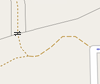 | 100 × 84 (4 KB) | Sergionaranja (talk | contribs) | 100px wide | |
| 08:19, 29 January 2009 | 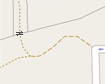 | 105 × 84 (4 KB) | Sergionaranja (talk | contribs) | mapnik renderization of key barrier=fence, grey line. |
You cannot overwrite this file.
File usage
More than 100 pages use this file. The following list shows the first 100 pages that use this file only. A full list is available.
- Ar:Map Features
- Az:Map Features
- Bs:Map Features
- Cs:Key:barrier
- Cs:Map Features
- Cs:Tag:barrier=chain
- Cs:Tag:barrier=ditch
- Cs:Tag:barrier=fence
- Cs:Tag:barrier=guard rail
- Cs:Tag:barrier=handrail
- Cs:Tag:barrier=retaining wall
- Cs:Tag:barrier=wall
- Da:Map Features
- El:Map Features
- Hr:Map Features
- Hu:Key:barrier
- Hu:Map Features
- Id:Map Features
- Key:barrier
- OSM Garrigues:Glossaire Garrigues Histoire
- Pl:Tag:barrier=chain
- Pl:Tag:barrier=ditch
- Pl:Tag:barrier=fence
- Pl:Tag:barrier=guard rail
- Pl:Tag:barrier=handrail
- Pl:Tag:barrier=retaining wall
- Pl:Tag:barrier=wall
- Pt:Key:barrier
- Pt:Map Features
- Pt:Tag:barrier=ditch
- Pt:Tag:barrier=fence
- Pt:Tag:barrier=retaining wall
- Pt:Tag:barrier=wall
- Ro:Map Features
- Tag:barrier=chain
- Tag:barrier=ditch
- Tag:barrier=fence
- Tag:barrier=guard rail
- Tag:barrier=handrail
- Tag:barrier=retaining wall
- Tag:barrier=wall
- Uk:Key:barrier
- Uk:Tag:barrier=retaining wall
- Uk:Об'єкти мапи
- Zh-hans:Tag:barrier=wall
- Zh-hant:Map Features
- Zh-hant:Map Features:barrier
- User:Gmbo/Motorrad
- Template:Ar:Map Features:barrier
- Template:Az:Map Features:barrier
- Template:Bs:Map Features:barrier
- Template:Cs:Map Features:barrier
- Template:DE:Map Features:barrier
- Template:Da:Map Features:barrier
- Template:El:Map Features:barrier
- Template:Et:Map Features:barrier
- Template:Hr:Map Features:barrier
- Template:Hu:Map Features:barrier
- Template:Id:Map Features:barrier
- Template:JA:Map Features:barrier
- Template:NL:Map Features:barrier
- Template:Pt:Map Features:barrier
- Template:RU:Generic:Map Features:barrier
- Template:Ro:Map Features:barrier
- Template:Sv:Map Features:barrier
- Template:Uk:Map Features:barrier
- Template:Zh-hant:Map Features:barrier
- DE:Key:barrier
- DE:Map Features
- DE:Tag:barrier=ditch
- DE:Tag:barrier=fence
- DE:Tag:barrier=retaining wall
- DE:Tag:barrier=wall
- FR:Tag:barrier=retaining wall
- FR:Tag:barrier=wall
- ES:Tag:barrier=chain
- ES:Tag:barrier=fence
- ES:Tag:barrier=guard rail
- ES:Tag:barrier=retaining wall
- ES:Tag:barrier=wall
- IT:Tag:barrier=ditch
- IT:Tag:barrier=fence
- IT:Tag:barrier=retaining wall
- NL:Kaartelementen
- NL:Key:barrier
- NL:Tag:barrier=fence
- RU:Key:barrier
- RU:Tag:barrier=ditch
- RU:Tag:barrier=fence
- RU:Tag:barrier=handrail
- RU:Tag:barrier=retaining wall
- RU:Tag:barrier=wall
- RU:Объекты карты
- JA:Key:barrier
- JA:Map Features
- JA:Tag:barrier=chain
- JA:Tag:barrier=ditch
- JA:Tag:barrier=fence
- JA:Tag:barrier=guard rail
- JA:Tag:barrier=handrail
View more links to this file.