File:Bombed hangars.jpg
Jump to navigation
Jump to search

No higher resolution available.
Bombed_hangars.jpg (480 × 600 pixels, file size: 73 KB, MIME type: image/jpeg)
Summary
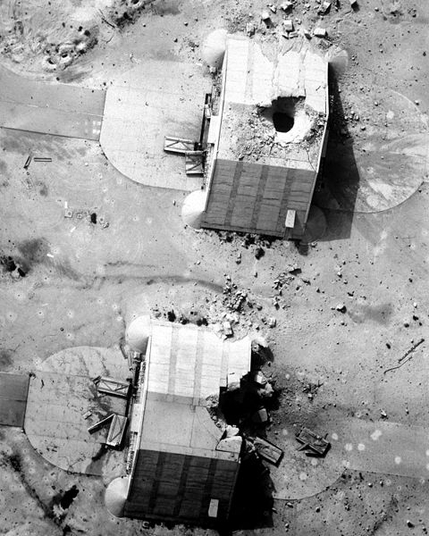
Two reinforced concrete aircraft hangars at the Ahmed Al Jaber Airfield show the results of a coalition bombing strike during Operation Desert Storm. The hangars had been suspected of housing Iraqi aircraft. The photograph was taken from a Fighter Squadron 84 (VF-84) F-14A Tomcat aircraft using the Tactical Air Reconnaissance Pod System (TARPS).
Even now after 20 years the bunker hits can be counted. Googlemaps shows 13 objects with a demolished roof. One bunker is missing, probably disassambled.
Photo credit: sailor or employee of the U.S. Navy.
Licensing
![]()
This file has been released into the public domain by the copyright holder, its copyright has expired, or it is ineligible for copyright. This applies worldwide.
Please, please use more specific template such as {{PD-self}} / {{PD-creator}} / {{PD-shape}} / {{PD-USGov}} / {{PD-old}} / {{PD-RU-exempt}} ... This template is not making clear why this work is in the public domain.
Please, please use more specific template such as {{PD-self}} / {{PD-creator}} / {{PD-shape}} / {{PD-USGov}} / {{PD-old}} / {{PD-RU-exempt}} ... This template is not making clear why this work is in the public domain.
File history
Click on a date/time to view the file as it appeared at that time.
| Date/Time | Thumbnail | Dimensions | User | Comment | |
|---|---|---|---|---|---|
| current | 22:37, 12 August 2013 | | 480 × 600 (73 KB) | Danrok (talk | contribs) | Two reinforced concrete aircraft hangars at the Ahmed Al Jaber Airfield show the results of a coalition bombing strike during Operation Desert Storm. The hangars had been suspected of housing Iraqi aircraft. The photograph was taken from a Fighter Squa... |
You cannot overwrite this file.