File:Br-classificacao-niteroi-rj-plano-diretor.jpg
Jump to navigation
Jump to search


Size of this preview: 760 × 600 pixels. Other resolutions: 304 × 240 pixels | 608 × 480 pixels | 973 × 768 pixels | 1,024 × 808 pixels.
Original file (1,024 × 808 pixels, file size: 236 KB, MIME type: image/jpeg)
Summary
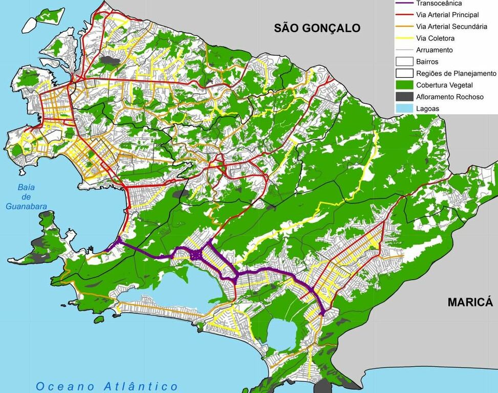
Classificação oficial segundo o plano diretor, publicada em 2 de outubro de 2017.
Disponível oficialmente no site da Prefeitura, neste link direto > Revisão do plano diretor > Biblioteca digital do Plano Diretor em:
- Diagnóstico Técnico - Volume 2/3 > 7.4 Infraestrutura viária > Figura 7.4.1 - Mapa da hierarquização viária do Município de Niterói, pág. 46; ou
- Diagnóstico Técnico - Volume 3/3 - Caderno de Mapas > Mapa 7.4.1 Hierarquização viária da cidade de Niterói
Licensing
![]()
This file has been released into the public domain by the copyright holder, its copyright has expired, or it is ineligible for copyright. This applies worldwide.
Please, please use more specific template such as {{PD-self}} / {{PD-creator}} / {{PD-shape}} / {{PD-USGov}} / {{PD-old}} / {{PD-RU-exempt}} ... This template is not making clear why this work is in the public domain.
Please, please use more specific template such as {{PD-self}} / {{PD-creator}} / {{PD-shape}} / {{PD-USGov}} / {{PD-old}} / {{PD-RU-exempt}} ... This template is not making clear why this work is in the public domain.
File history
Click on a date/time to view the file as it appeared at that time.
| Date/Time | Thumbnail | Dimensions | User | Comment | |
|---|---|---|---|---|---|
| current | 03:22, 13 December 2020 | | 1,024 × 808 (236 KB) | Ftrebien (talk | contribs) | Classificação oficial segundo o plano diretor, publicada em 2 de outubro de 2017. Disponível oficialmente no site da [http://www.niteroi.rj.gov.br/ Prefeitura], [https://urbanismo.niteroi.rj.gov.br/ neste link direto] > [https://urbanismo.niteroi.rj.gov.br/planodiretor/ Revisão do plano diretor] > Biblioteca digital do Plano Diretor em: * [http://urbanismo.niteroi.rj.gov.br/wp-content/uploads/2015/10/diagnostico-tecnico-volume-2-3.pdf Diagnóstico Técnico - Volume 2/3] > 7.4 Infraestrutura vi... |
You cannot overwrite this file.
File usage
The following page uses this file: