File:ConnectivityExample8.png
Jump to navigation
Jump to search


Size of this preview: 800 × 443 pixels. Other resolutions: 320 × 177 pixels | 640 × 355 pixels | 951 × 527 pixels.
Original file (951 × 527 pixels, file size: 764 KB, MIME type: image/png)
Summary
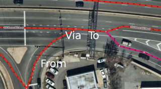
A complex intersection where turn:lanes won't work properly unless the intersection is remodeled into some ridiculous shape that would make mapping other things (such as change:lanes) much more difficult. The image is Mapbox Satellite in iD of this location: https://www.osm.org/#map=19/38.77908/-77.18408
![]()
This image is composed partially or entirely of imagery from Mapbox.
The Mapbox imagery is not open licensed, but is made available to the OpenStreetMap project for deriving open licensed map data (see Mapbox page for details). This image is used for illustrative purposes on the OpenStreetMap wiki, to help document ways of using and interpreting the imagery in the OpenStreetMap mapping process and is used here with Mapbox's express permission for that purpose.
The Mapbox imagery is not open licensed, but is made available to the OpenStreetMap project for deriving open licensed map data (see Mapbox page for details). This image is used for illustrative purposes on the OpenStreetMap wiki, to help document ways of using and interpreting the imagery in the OpenStreetMap mapping process and is used here with Mapbox's express permission for that purpose.
File history
Click on a date/time to view the file as it appeared at that time.
| Date/Time | Thumbnail | Dimensions | User | Comment | |
|---|---|---|---|---|---|
| current | 00:04, 12 June 2019 | | 951 × 527 (764 KB) | LeifRasmussen (talk | contribs) | A complex intersection where turn:lanes won't work properly unless the intersection is remodeled into some ridiculous shape that would make mapping other things (such as change:lanes) much more difficult. The image is Mapbox Satellite in iD of this loc... |
You cannot overwrite this file.
File usage
The following 3 pages use this file: