File:Gpx graffiti vandalism.png
Jump to navigation
Jump to search


Size of this preview: 800 × 476 pixels. Other resolutions: 320 × 191 pixels | 640 × 381 pixels | 1,024 × 610 pixels | 1,280 × 762 pixels | 1,898 × 1,130 pixels.
Original file (1,898 × 1,130 pixels, file size: 173 KB, MIME type: image/png)
Summary
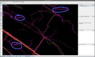
Vandalism in the form of graffiti in GPS tracks. This makes it harder to develop automatic data processing tools based on OSM GPS tracks. This screenshot shows three words in the Thessaloniki (Greece) area written as GPS tracks, as viewed in JOSM. The coordinates are in the lower left corner. The graffiti give the correct names of landmarks, but this is not the proper way to signal this type of information.
Licensing
![]()
This file is a JOSM screenshot, without imagery in a background.
![]()
"JOSM" (Java OpenStreetMap Editor – josm.openstreetmap.de) is free software released under the terms of the GNU General Public License as published by the Free Software Foundation; either version 2 of the license, or any later version.
File history
Click on a date/time to view the file as it appeared at that time.
| Date/Time | Thumbnail | Dimensions | User | Comment | |
|---|---|---|---|---|---|
| current | 12:08, 19 April 2012 | | 1,898 × 1,130 (173 KB) | Mayeul (talk | contribs) | Blue circles to emphasise the 3 words. |
| 12:04, 19 April 2012 |  | 1,898 × 1,130 (147 KB) | Mayeul (talk | contribs) | Vandalism in the form of graffiti in GPS tracks. This makes harder any attempt to develop automatic data processing tools based on OSM GPS tracks. This screenshot shows 3 words written as GPS tracks, in the Thessaloniki (Greece) area, viewed on JOSM. The |
You cannot overwrite this file.
File usage
The following 14 pages use this file: