File:IOW nodes small.png
Jump to navigation
Jump to search


No higher resolution available.
IOW_nodes_small.png (300 × 257 pixels, file size: 27 KB, MIME type: image/png)
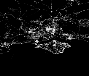
Map of Isle of Wight
This map and others like it, were created by OpenStreetmap contributors, and are licensed as Creative Commons CC-BY-SA 2.0 (https://creativecommons.org/licenses/by-sa/2.0/) (see OpenStreetMap licence).
Use {{mapof|PlaceName}} to add this template to your images.
This map and others like it, were created by OpenStreetmap contributors, and are licensed as Creative Commons CC-BY-SA 2.0 (https://creativecommons.org/licenses/by-sa/2.0/) (see OpenStreetMap licence).
Use {{mapof|PlaceName}} to add this template to your images.
Full-size version:

This is a Featured image, which means that it has been identified as one of the best examples of OpenStreetMap mapping, or that it provides a useful illustration of the OpenStreetMap project. If you know another image of similar quality, you can nominate it on Featured image proposals.
Front-page image on 11 Nov 2006
File history
Click on a date/time to view the file as it appeared at that time.
| Date/Time | Thumbnail | Dimensions | User | Comment | |
|---|---|---|---|---|---|
| current | 21:50, 7 November 2006 | | 300 × 257 (27 KB) | Ojw (talk | contribs) | Image:Osmnodes.png |
You cannot overwrite this file.
File usage
The following 3 pages use this file: