File:Make river landsat.png
Jump to navigation
Jump to search

No higher resolution available.
Make_river_landsat.png (704 × 133 pixels, file size: 194 KB, MIME type: image/png)
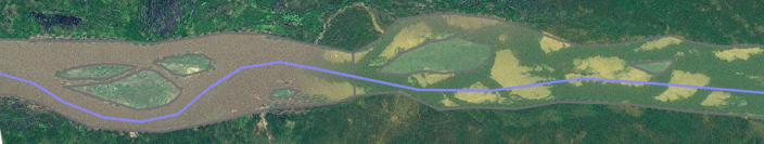
I like to mark riverbanks on its high-water extent, including sandbanks. Therefore non-permanent islands (sandbanks) are also included, only permanent islands are marked.
http://www.openstreetmap.org/?lat=8.0224&lon=7.5918&zoom=13 Imagery:
![]()
.svg)
This work is in the public domain in the United States because it is a work of the United States Federal Government under the terms of Title 17, Chapter 1, Section 105 of the US Code. See Copyright.
Note: This only applies to works of the Federal Government and not to the work of any individual U.S. states, territory, commonwealth, county, municipality, or any other subdivision. This template also does not apply to postage stamp designs published by the United States Postal Service since 1978. (See 206.02(b) of Compendium II: Copyright Office Practices).
Note: This only applies to works of the Federal Government and not to the work of any individual U.S. states, territory, commonwealth, county, municipality, or any other subdivision. This template also does not apply to postage stamp designs published by the United States Postal Service since 1978. (See 206.02(b) of Compendium II: Copyright Office Practices).
File history
Click on a date/time to view the file as it appeared at that time.
| Date/Time | Thumbnail | Dimensions | User | Comment | |
|---|---|---|---|---|---|
| current | 22:17, 5 September 2009 | 704 × 133 (194 KB) | Bass (talk | contribs) | I like to mark riverbanks on its high-water extent, including sandbanks. Therefore non-permanent islands (sandbanks) are also included, only permanent islands are marked. |
You cannot overwrite this file.