File:Mexico City earthquake mapping event.jpg
Jump to navigation
Jump to search


Size of this preview: 800 × 450 pixels. Other resolutions: 320 × 180 pixels | 640 × 360 pixels | 1,024 × 576 pixels.
Original file (1,024 × 576 pixels, file size: 129 KB, MIME type: image/jpeg)
Summary
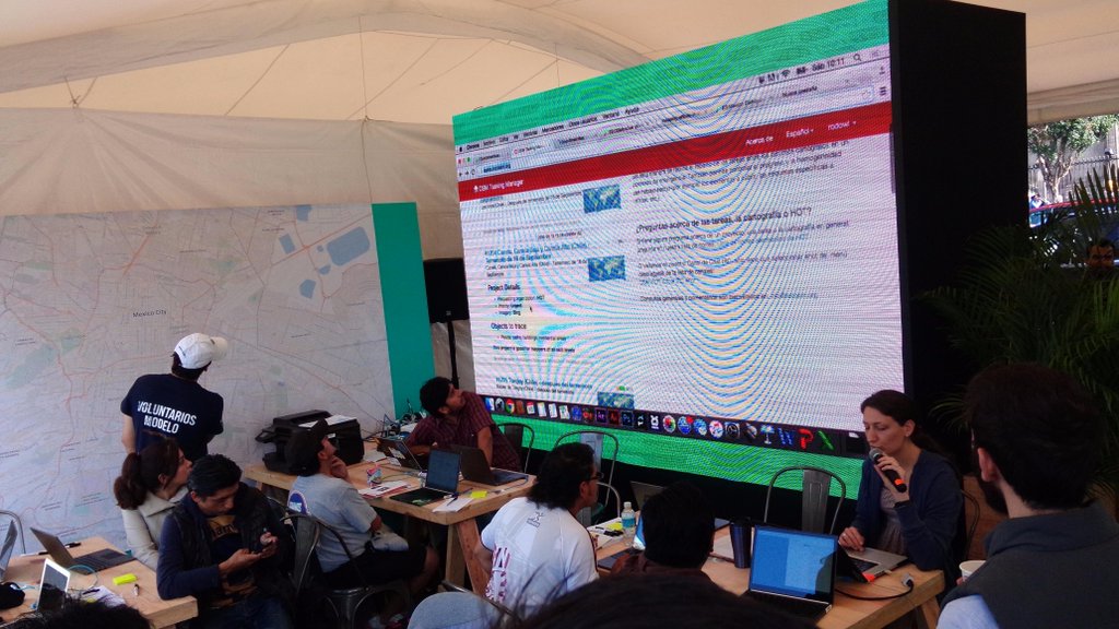
An earthquake preparedness event in Mexico City. Photo tweeted: https://twitter.com/mapeadora/status/675152304333570051
This is a Featured image, which means that it has been identified as one of the best examples of OpenStreetMap mapping, or that it provides a useful illustration of the OpenStreetMap project. If you know another image of similar quality, you can nominate it on Featured image proposals.
Front-page image for week 53 of 2015 (28 Dec. – 3 Jan.).
- Image descriptions
- asturianu : Un 'Simulacro Nacional' (exerciciu nacional de terremotu) tuvo llugar na Ciudá de Mexicu, con delles actividaes dixitales de preparación pa un desastre, incluyendo una gran sesión d'entrenamientu n'OpenStreetMap
- Bahasa Indonesia : 'Simulacro Nacional' (National Earthquake Bor) berlangsung di Mexico City, dengan berbagai kegiatan kesiapsiagaan bencana digital termasuk sesi pelatihan OpenStreetMap besar
- English : 'Simulacro Nacional' (National Earthquake Drill) took place in Mexico City, with a variety of digital disaster preparedness activities including a big OpenStreetMap training session
- italiano : «Simulacro Nacional» (Esercitazione nazionale sui terremoti) si è svolta a Città del Messico, con svariate attività digitali di preparazione ai disastri inclusa una estesa sessione di formazione su OpenStreetMap.
- русский : В Мехико прошла Национальная подготовка к землетрясениями (‘Simulacro Nacional’). На одном из тренингов участникам объясняли, как работать с данными ОСМа.
- 中文(简体) : 'Simulacro Nacional' (国家地震演习)在墨西哥市举行,许多数位灾害防治活动,包括参与人数众多的开放街图训练课程
- 中文(繁體) : 'Simulacro Nacional' (國家地震演習)在墨西哥市舉行,許多數位災害防治活動,包括參與人數眾多的開放街圖訓練課程
Licensing
![]()
![]()
![]()
This work is licensed under the Creative Commons Attribution-ShareAlike 2.0 License.
Attribution not specified as a parameter! THIS LICENSE ALWAYS REQUIRES ATTRIBUTION! Use {{CC-BY-SA-2.0|Attribution, typically name of author}} See Template:CC-BY-SA-2.0 for full description how this template should be used.
Note, there is
There is also
Attribution not specified as a parameter! THIS LICENSE ALWAYS REQUIRES ATTRIBUTION! Use {{CC-BY-SA-2.0|Attribution, typically name of author}} See Template:CC-BY-SA-2.0 for full description how this template should be used.
Note, there is
{{CC-BY-SA-2.0 OpenStreetMap}} for files based on old OSM map data, before the license change made on 2012-09-12.There is also
{{OSM Carto screenshot||old_license}} for files based on old OSM map data, before the license change made on 2012-09-12, created using OSM Carto map style.
File history
Click on a date/time to view the file as it appeared at that time.
| Date/Time | Thumbnail | Dimensions | User | Comment | |
|---|---|---|---|---|---|
| current | 13:02, 15 December 2015 | | 1,024 × 576 (129 KB) | Harry Wood (talk | contribs) | An earthquake preparedness event in Mexico City. Photo tweeted: https://twitter.com/mapeadora/status/675152304333570051 |
You cannot overwrite this file.