File:Philippines node density increase animation.gif
Jump to navigation
Jump to search


Size of this preview: 369 × 599 pixels. Other resolutions: 148 × 240 pixels | 524 × 850 pixels.
Original file (524 × 850 pixels, file size: 1.65 MB, MIME type: image/gif, looped, 29 frames, 8.8 s)
Note: Due to technical limitations, thumbnails of high resolution GIF images such as this one will not be animated.
Information
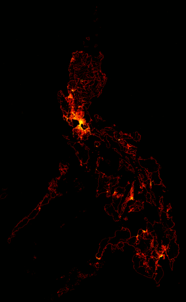
| Description | This is a animation of the node density of OSM data in the Philippines from 2012-01-02 to 2013-09-30. Each pixel represents a 0.02°×0.02° degree square or approximately 4 square kilometers. Brighter pixels represent areas with higher node count increase. |
|---|---|
| Author | seav |
| Source | Animated outputs of a custom script that processes Philippine OSM extracts. |
| Date | 2013-10-03 |
| Permission |
This work is licensed under the Creative Commons Attribution-ShareAlike 2.0 License.
Attribution: seav
|
| Other versions |


File history
Click on a date/time to view the file as it appeared at that time.
| Date/Time | Thumbnail | Dimensions | User | Comment | |
|---|---|---|---|---|---|
| current | 15:23, 3 October 2013 | | 524 × 850 (1.65 MB) | Seav (talk | contribs) | ==Information== {{Information |Description = This is a animation of the node density of OSM data in the Philippines from 2012-01-02 to 2013-09-30. Each pixel represents a 0.02°×0.02° degree square or approximately 4 square kilometers. Brighter pi... |
You cannot overwrite this file.
File usage
There are no pages that use this file.