File:Portland snip001.png
Jump to navigation
Jump to search


Size of this preview: 313 × 600 pixels. Other resolutions: 125 × 240 pixels | 250 × 480 pixels | 818 × 1,567 pixels.
Original file (818 × 1,567 pixels, file size: 906 KB, MIME type: image/png)
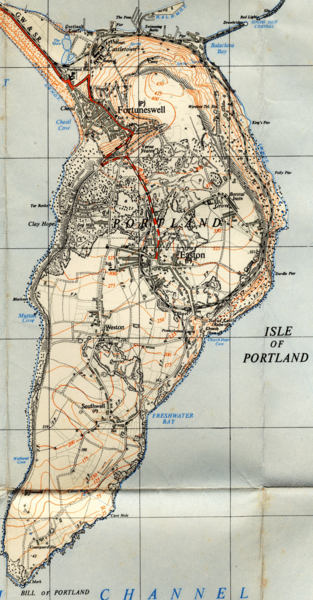
OS 1:25,000 scale mapping of Isle of Portland on the south coast of England. An extract from Sheet 30/67 (SY67) of 1948. The original was scanned at 300dpi but the image size here has been reduced by half to provide a manageable file size of 1MB for the wiki download, but you can also browse it on ooc.openstreetmap.org (Note: The example may take a short period to fully load on some systems, so be patient).
File history
Click on a date/time to view the file as it appeared at that time.
| Date/Time | Thumbnail | Dimensions | User | Comment | |
|---|---|---|---|---|---|
| current | 11:36, 27 August 2009 | | 818 × 1,567 (906 KB) | Blackadder (talk | contribs) | OS 1:25,000 scale mapping of Isle of Portland on the south coast of England. An extract from Sheet 30/67 (SY67) of 1948 |
You cannot overwrite this file.
File usage
The following page uses this file: