File:Projeteof togo.PNG
Jump to navigation
Jump to search


Size of this preview: 800 × 533 pixels. Other resolutions: 320 × 213 pixels | 640 × 427 pixels | 960 × 640 pixels.
Original file (960 × 640 pixels, file size: 1.31 MB, MIME type: image/png)
Summary
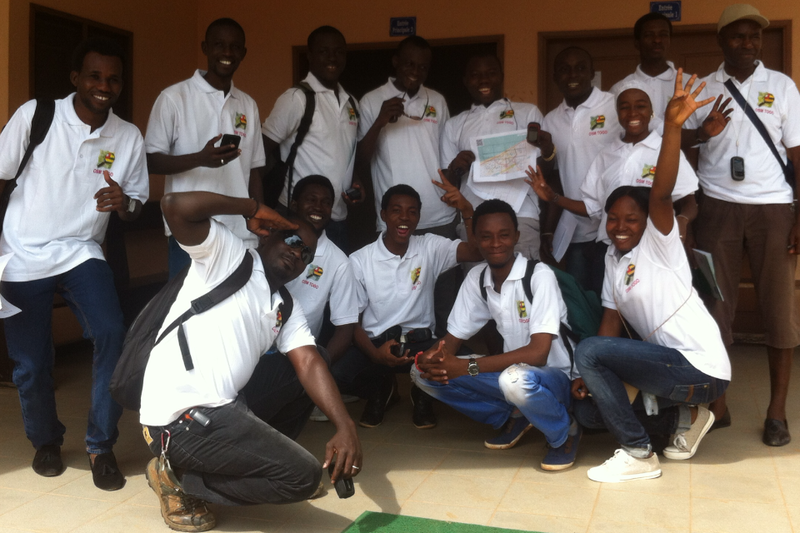
Western african OpenStreetMap communities gathering in Lomé (Togo) : massive data collection preparedeness.
This is a Featured image, which means that it has been identified as one of the best examples of OpenStreetMap mapping, or that it provides a useful illustration of the OpenStreetMap project. If you know another image of similar quality, you can nominate it on Featured image proposals.
Front-page image for week 44 of 2014 (27 Oct. – 2 Nov.).
- Image descriptions
- Deutsch : Die Organisation Internationale de la Francophonie (OIF) wirbt in Afrika – insbesondere im französischsprachigen Afrika – für OpenStreetMap. Aus diesem Anlass trafen sich Mapper aus Togo, Senegal, Burkina Faso, Niger, der Elfenbeinküste und Benin in Lomé.
- English : OpenStreetMap mappers from Togo, Senegal, Burkina Faso, Niger, Côte d'Ivoire and Benin, meeting in Lomé. International Organisation internationale de la Francophonie (OIF) is promoting OpenStreetMap in Africa, particularly in the french speaking countries
- français : Des cartographieurs d'OpenStreetMap du Togo, du Sénégal, du Burkina Faso, du Niger, de Côte d'Ivoire et du Bénin, se sont rencontrés à Lomé. l'Organisation internationale de la Francophonie (OIF) promeut OpenStreetMap en Afrique, et en particulier dans les pays fracophones.
- italiano : Mappatori da Togo, Senegal, Burkina Faso, Niger, Côte d'Ivoire e Benin, si sono incontrati a Lomé. La Organisation internationale de la Francophonie (OIF) sta promuovendo OpenStreetMap in Africa, specialmente nei Paesi dove si parla francese.
- русский : Международная организация Франкофония помогает продвигать ОпенСтритМап в Африке, в особенности во франкоязычных странах. Эта фотография сделана во время встречи картографов из Того, Сенегала, Буркина-Фасо, Нигера, Кот-д’Ивуара и Бенина в городе Ломе (столице Того).
- 中文(繁體) : 來自東加、塞內加爾、布吉納法索、尼日、象牙海岸和貝南的開放街圖圖客,在洛美舉行的 International Organisation internationale de la Francophonie (OIF)大會上聚會,討論如何在非洲推廣開放街圖,特別是說法語的國家。
Licensing
![]()
![]()
![]()
This work is licensed under the Creative Commons Attribution-ShareAlike 2.0 License.
Attribution not specified as a parameter! THIS LICENSE ALWAYS REQUIRES ATTRIBUTION! Use {{CC-BY-SA-2.0|Attribution, typically name of author}} See Template:CC-BY-SA-2.0 for full description how this template should be used.
Note, there is
There is also
Attribution not specified as a parameter! THIS LICENSE ALWAYS REQUIRES ATTRIBUTION! Use {{CC-BY-SA-2.0|Attribution, typically name of author}} See Template:CC-BY-SA-2.0 for full description how this template should be used.
Note, there is
{{CC-BY-SA-2.0 OpenStreetMap}} for files based on old OSM map data, before the license change made on 2012-09-12.There is also
{{OSM Carto screenshot||old_license}} for files based on old OSM map data, before the license change made on 2012-09-12, created using OSM Carto map style.
File history
Click on a date/time to view the file as it appeared at that time.
| Date/Time | Thumbnail | Dimensions | User | Comment | |
|---|---|---|---|---|---|
| current | 12:16, 5 October 2014 | | 960 × 640 (1.31 MB) | Ndong Potter (talk | contribs) | Western african OpenStreetMap communities gathering in Lomé (Togo) : massive data collection preparedeness. |
You cannot overwrite this file.