File:Rendering-landuse-construction-mapnik.png
Jump to navigation
Jump to search


No higher resolution available.
Rendering-landuse-construction-mapnik.png (125 × 125 pixels, file size: 354 bytes, MIME type: image/png)
Summary
OSM Carto rendering for:
Source: https://github.com/gravitystorm/openstreetmap-carto/commit/b0a74a5e4b4b839daeb9792220af257e50b32180
Licensing
![]()
This image or logo only consists of typefaces, individual words, slogans, or simple geometric shapes. These are not eligible for copyright alone because they are not original enough, and thus the image is considered to be in the public domain.
See Public domain or Restricted materials on Wikipedia for more information.
Please note: The public domain status of this work is only in regards to its copyright status. There may be other intellectual property restrictions protecting this image, such as trademarks or design patents if it is a logo.
See
Please note: The public domain status of this work is only in regards to its copyright status. There may be other intellectual property restrictions protecting this image, such as trademarks or design patents if it is a logo.
File history
Click on a date/time to view the file as it appeared at that time.
| Date/Time | Thumbnail | Dimensions | User | Comment | |
|---|---|---|---|---|---|
| current | 12:59, 13 September 2016 | | 125 × 125 (354 bytes) | Geozeisig (talk | contribs) | https://github.com/gravitystorm/openstreetmap-carto/commit/b0a74a5e4b4b839daeb9792220af257e50b32180 |
| 11:50, 18 May 2014 |  | 125 × 125 (2 KB) | Mabull (talk | contribs) | ||
| 07:38, 25 May 2009 | 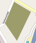 | 152 × 182 (6 KB) | UrSuS (talk | contribs) |
You cannot overwrite this file.
File usage
More than 100 pages use this file. The following list shows the first 100 pages that use this file only. A full list is available.
- Ar:Map Features
- Ast:Map Features
- Az:Map Features
- Bg:Map Features
- Bs:Map Features
- Cs:Key:landuse
- Cs:Map Features
- Cs:Tag:landuse=brownfield
- Cs:Tag:landuse=construction
- Cs:Tag:landuse=greenfield
- Da:Map Features
- El:Map Features
- Eo:Map Features
- Fa:Map Features
- Fi:Kartan ominaisuudet
- He:Map Features
- Hr:Map Features
- Hu:Key:landuse
- Hu:Map Features
- Id:Map Features
- Id:Penggunaan Lahan
- Kathmandu Living Labs/2CPokhara
- Key:landuse
- Ko:지도 지물
- Lt:Map Features
- Lv:Land use
- Lv:Map Features
- Map features
- Ne:Map Features
- Nepal/Nilkantha
- Pl:Key:landuse
- Pl:Tag:landuse=brownfield
- Pl:Tag:landuse=construction
- Pl:Tag:landuse=greenfield
- Pl:Tag:landuse=industrial
- Projet Garrigue
- Pt:Key:landuse
- Pt:Map Features
- Pt:Tag:landuse=brownfield
- Ro-md:Map Features
- Ro:Map Features
- Sr:Map Features
- Sv:Map Features
- Tag:landuse=brownfield
- Tag:landuse=construction
- Tag:landuse=greenfield
- Uk:Key:landuse
- Uk:Об'єкти мапи
- Zh-hans:Key:landuse
- Zh-hans:Map Features
- Zh-hant:Map Features
- User:Chillly/Simple Map Features
- User:H4ck3rm1k3/OSMKeys
- Template:Ar:Map Features:landuse
- Template:Az:Map Features:landuse
- Template:Bs:Map Features:landuse
- Template:Ca:Map Features:landuse
- Template:Cs:Map Features:landuse
- Template:DE:Map Features:landuse
- Template:Da:Map Features:landuse
- Template:El:Map Features:landuse
- Template:Et:Map Features:landuse
- Template:FR:Map Features:landuse
- Template:Fi:Map Features:landuse
- Template:Hr:Map Features:landuse
- Template:Hu:Map Features:landuse
- Template:IT:Map Features:landuse
- Template:Id:Map Features:landuse
- Template:JA:Map Features:landuse
- Template:Map Features:landuse
- Template:Map Features:landuse/doc
- Template:NL:Map Features:landuse
- Template:Pl:Map Features:landuse
- Template:Pt:Map Features:landuse
- Template:RU:Map Features:landuse
- Template:Uk:Map Features:landuse
- Template:Zh-hans:Map Features:landuse
- Template:Zh-hant:Map Features:landuse
- DE:Key:landuse
- DE:Map Features
- DE:Tag:landuse=brownfield
- DE:Tag:landuse=construction
- DE:Tag:landuse=greenfield
- FR:Key:landuse
- FR:Standard tile layer
- FR:Tag:landuse=construction
- FR:Éléments cartographiques
- ES:Tag:landuse=brownfield
- ES:Tag:landuse=construction
- IT:Key:landuse
- IT:Map Features
- IT:Tag:landuse=construction
- NL:Kaartelementen
- NL:Key:landuse
- RU:Key:landuse
- RU:Tag:landuse=brownfield
- RU:Tag:landuse=construction
- JA:Key:landuse
- JA:Map Features
- JA:Tag:landuse=brownfield
View more links to this file.