File:Umlaufgitter.jpg
Jump to navigation
Jump to search


Size of this preview: 800 × 600 pixels. Other resolutions: 320 × 240 pixels | 640 × 480 pixels | 1,024 × 768 pixels | 1,280 × 960 pixels | 2,592 × 1,944 pixels.
Original file (2,592 × 1,944 pixels, file size: 3.2 MB, MIME type: image/jpeg)
This file and its description are from Wikimedia Commons.
Summary
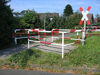
Deutsch: Ein Umlaufgitter an einem Bahnübergang um zu verhindern, dass Menschen unachtsam über die Schienen laufen und als Hindernis für Radfahrer.
Fotografiert von Michael Krahe am 5. September 2005.
English: A fence to prevent people from running across the track at a railroad crossing.
Photo by Michael Krahe, 2005-09-05.
The name of this in German: “Umlaufsperre”.| Camera location | | View this and other nearby images on: OpenStreetMap |
|---|
Licensing
I, the copyright holder of this work, hereby publish it under the following licenses:

|
Permission is granted to copy, distribute and/or modify this document under the terms of the GNU Free Documentation License, Version 1.2 or any later version published by the Free Software Foundation; with no Invariant Sections, no Front-Cover Texts, and no Back-Cover Texts. A copy of the license is included in the section entitled GNU Free Documentation License. |
| This file is licensed under the Creative Commons Attribution-Share Alike 3.0 Unported license. | ||
| ||
| This licensing tag was added to this file as part of the GFDL licensing update. |
You may select the license of your choice.
File history
Click on a date/time to view the file as it appeared at that time.
| Date/Time | Thumbnail | Dimensions | User | Comment | |
|---|---|---|---|---|---|
| current | 12:31, 5 September 2005 | | 2,592 × 1,944 (3.2 MB) | wikimediacommons>MichiK | A so called "Umlaufgitter" to prevent people from running across the tracks at a railroad crossing.<br /> Photo by Michael Krahe, 2005-09-05. |
File usage
The following 2 pages use this file: