File:WaltonOnThamesMap.png
Jump to navigation
Jump to search


Size of this preview: 649 × 600 pixels. Other resolutions: 260 × 240 pixels | 520 × 480 pixels | 1,000 × 924 pixels.
Original file (1,000 × 924 pixels, file size: 196 KB, MIME type: image/png)
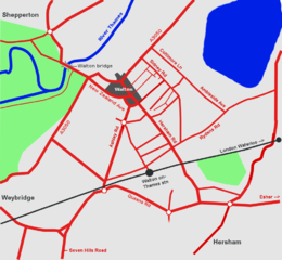
Walton on Thames (also at http://en.wikipedia.org/wiki/Image:WaltonOnThamesMap.png)
Image was traced from the plain white OpenStreetMap segments, Landsat photography, and local knowledge using the GIMP
File history
Click on a date/time to view the file as it appeared at that time.
| Date/Time | Thumbnail | Dimensions | User | Comment | |
|---|---|---|---|---|---|
| current | 14:56, 1 July 2006 | | 1,000 × 924 (196 KB) | Ojw (talk | contribs) | Walton on Thames (also at http://en.wikipedia.org/wiki/Image:WaltonOnThamesMap.png) |
You cannot overwrite this file.
File usage
The following file is a duplicate of this file (more details):
- File:WaltonOnThamesMap.png from Wikimedia Commons
The following page uses this file: