JA:マウンテンバイク

|
| 説明 |
| マウンテンバイクのルート |
| タグ |
![]()
英語版の記事の内容が分かる方は、翻訳の完成にご協力ください。このウィキの翻訳方法についての説明をお読みください。
現時点では、誰もこの記事の翻訳に取り組んでいないようですので、あなたが取り組めます。
![]()
このページについて
The goal of this page is to help create OSM maps from a mountain bikers perspective. This page is a translation of the German version that started the topic. This is to be made an official proposal (please help!) with voting taking place as soon as possible. This page is created so that there will be consistent tagging of mtb related features to tracks and paths. Please help me in putting up the proposals and voicing your support so that mountainbikers can be sure of how to quickly tag ways and knowing that they can profit from it getting mtb specific maps once the renderers have the certainity of how the ways are mapped.
For any "Newcomers". Please discuss proposals on the Proposed_features parts rather than on the talk page here, and also look for the newest decisions regarding how to tag. I think everyone will try to get an easy but specific enough feature set setup that will cover our needs as mountainbikers. Please take part in the discussions if you can think of ways how to do it better. In a few days when the Drafts have gone to RFC I will try to actualise this page with the Proposals. Currently there are some discrepancies.--Extremecarver 22:42, 20 November 2008 (UTC)
- Proposed_features/mtb:type provide the general usage class of a trail. i.e. cross country, all mountain, downhill, freeride, north shore, etc.
- Proposed_features/mtb_access provide a legal right of access for mountain bikes, hours, days, temporarily closure
- Proposed_features/trail_feature provide location and type of feature. i.e. ramp, jump, rock face
| key | comment |
|---|---|
| highway=path/track | if a way is tagged highway=footway and mtbiking is possible change to highway=path foot=designated |
| foot=yes/no/designated/private/permissive/destination/unknown | - |
| bicycle=yes/no/designated/private/permissive/destination/dismount/unknown | Is cycling allowed? This is only a legal question. |
| width=<Meter> | Width of way |
| surface=ground/sand/stone/gravel/grass/dirt | - |
| smoothness=excellent to impassable | Classification scheme regarding the physical usability of a way for wheeled vehicles. |
| tracktype=grade1 to grade5 | Surface firmness,n usually used on highway=track. |
| trail_visibility=excellent/good/intermediate/bad/horrible/no | Trail visibility (not route visibility) and orientation. |
| key | comment | Proposal/Map Feature Page | Status/Progress |
|---|---|---|---|
| mtb:scale=0-6 | Difficulty grading for mtb use for level and downhill trails, also valid for ways that are no singletrails. Based on the German "Singletrailskala". | key:mtb:scale | Approved |
| mtb:scale:imba=0-4 | Difficulty grading for mtb use for built tracks. Mainly applicable to North America. | key:mtb:scale | Approved |
| mtb:scale:uphill=0-5 | Difficulty grading for mtb uphill use. Use if there is a significant inclination. | key:mtb:scale | Approved |
| incline=<incline in %> or up/down | How steep is a trail. Please use this tag in conjunction with mtb:scale:uphill to specify direction of way (uphill vs downhill). | Key:incline | Approved |
| mtb:type=crosscountry/allmountain/downhill/trial/freeride | Giving further Attributes to a trail from mountain biking perspective. Classify its usage. | Proposed_features/mtb:type | See commonly used values taginfo |
| mtb:description=any | Any Additional information related to mtbike use of a way. | Proposed_features/mtb:description | Approved |
| mtb:access=needs to be discussed | provide information about mtb access of trails, hours, days, temporarily closure.... | Proposed_features/mtb_access | Draft - Needs Ideas - Usage depends on other Proposals |
| mtb:name=any | Sometimes trails have names that are only used by mountainbikers and not official. Use mtb:name to specify them. This is not Key:loc_name | ||
| class:bicycle:mtb=-3 to 3 | Specify subjectively how well suited / how much fun it is to mtbike on a trail (possibility to choose "a line" of mtb:scale=0 and 1 - or only short sections that are very difficult) | Class:bicycle | |
| class:bicycle:mtb:technical=-3 to 3 | Specify subjectively how well suited / how much fun a trail is for enduro/freeride/trial mountainbikers (average mtb:scale=2 and up) | Class:bicycle | |
| aerialway:bicycle:=yes/summer/no | Specify if bicycles are transported on aerialways. For Gondolas, Cable_Cars and Mixed_lifts yes shall be assumed. For chairlifts, t-bars and others no is default. Use value summer, if bicycles/mtbikes are only transported during summer season. In general chairlifts and t-bars don't allow for bicycle transport, but more and more places, especially in bikeparks add hooks for bicycle transport (usually either 1 at the side, or as many as there are places at the back of the chair. | Proposed_features/Piste_Maps |
Relevant proposals that can accompany mtb tagged trails
| key | comment | needs proposal | Status/Progress |
|---|---|---|---|
| tourism=information information=map |
Information point with map of trails, typically found at the trailhead. | Proposed_features/information | Disputed use of access tags to describe object (see talk page), inactive but in use |
| tourism=information information=guidepost |
Information point with direction signs. | Proposed_features/Guidepost | |
| osmc:symbol=* | Notation system for trail symbols | Key:osmc:symbol | |
| trailblazed=yes | A way is marked with trailblazes | Proposed_features/trailblazed |
The above keys seem to be in use but keep track of eventual changes, they are indicated here to point out details that are very relevant to note while surveying, and a temporary tagging scheme allow us to store it.
Additional tags if a way is part of a MTB Route / Relation
Note network=* is not defined for mtb routes. Use distance/ascent/descent/roundtrip instead to better classify a route.
| key | comment |
|---|---|
| route=mtb | consistency with cycle and hiking routes. |
| ref=R811,... | Reference of the way if any. |
| name=Alpentour Austria,... | name of the route. |
| distance=distance in km | The distance covered by this route, if known. For information of users and automatic evaluation e.g. of completeness. If no unit is given km is assumed (else use e.g. 25miles) |
| ascent=ascent in m | The ascent covered by a route in meters (for other units use e.g. 600feet). If a route has start and end point at different altitude use descent too |
| descent=descent in m | The descent covered by a route in meters(for other units use e.g. 100feet). Use it only if it differs from the ascent (different altitude at start/endpoint of a route). |
| roundtrip=yes/no | Use roundtrip=no to indicate that a route goes from A to B, instead of being circular (roundtrip=yes). |
You can create your own maps including route=mtb for Garmin Units/Mapsource or Qlandkarte GT by following the procedure explained here however: OSM_Map_On_Garmin/mtb_map.
How to tag ways appropriate for mtbiking
JOSM now includes mtb:scale in the presets for paths and tracks. For incline and mtb:scale:uphill; mtb:description; mtb:scale:imba or others, you can add the keys and values by clicking on "add". For keys that are not available on a preset you can either add a mtb preset from here: http://josm.openstreetmap.de/wiki/Presets or directly entering the information by clicking on "ADD". JOSM Example:

With Potlatch after selecting a way click on the "+" icon:

And then replace key with the respective key, and enter the value into the gray type value here

Rendering of MTB maps

- VTTrack implements the MTB features on various underlying maps (OpenStreetMap, GoogleMaps, French Geoportail maps). It also includes other sources of MTB tours and trails, especially other sources whose tour/trail rating scale is mappable onto mtb:scale (UtagawaVTT.com, VTTour.fr, Singletrack.fr, Gulliver.it, cycloalpinismo.com).
- On OpenRouteService you can route from A to B with preference for mtb trails and routes.
- Mtbmap.cz rendering of both MTB features together with specific hiking trail markings (red/green/blue/yellow) in the Czech Republic, with the aim to generate maps comparable to the printed maps generated according to the Czech cartography standards. It also renders MTB features and supports rendering hiking trails using WayMarkedTrails overlay for the rest of Europe (overlay can be enabled via layers menu in the top right corner of the map). In the Czech Republic, the map also supports complex planning and optimization MTB trips (dynamic specification of preferences for various types of trails and roads) with generation of altitude profiles.
- 4UMaps implements MTB as well as hiking features. The map is optimized for outdoor activities with elevation lines, hill shading, accommodation etc. A free download of predefined maps is also available.
- mtbmap.se serves an online map with mountainbike focus. Covers Sweden, Norway, Denmark and Finland at the moment. At the same time an experiment of how to render very large areas with Maperitive.
- Rendering HikingBikingMaps: HikingBikingMaps
- Orienteering Map Specifications, including MTB-O
- MTB trails with altitude profiles, routing capabilities and GPX export: www.xctrails.org
- nice rendering for mtb's: Waymarked Trails
Rendering of MTB maps on Garmin units
You can download routable mountainbike maps for European countries, Alps, Australia/NewZealand, South America and Africa on Openmtbmap.org The maps support autorouting with preference for mtb trails and cycleways, and give visual display of mtb:scale; mtb:scale:uphill (taking incline into account for "downhill arrows") and route=mtb.
You can also create your own maps using mkgmap.
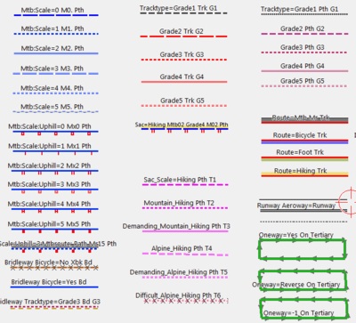
Map Legend in Mapsource
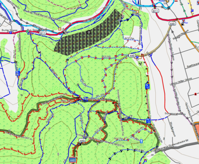
Example Area Anninger Moedling


Rendering on Android devices
Openandromaps provides vector maps and themes for MTB, hiking and biking. These can be used with Oruxmaps[1] or Locus[2] and provide information about mtb:scale and mtb:scale:uphill. The maps are in the mapsforge format and can also be used with other applications using implementing this format.
| Map legend | Example |
| Official MTB-Routes color codes for mtb:scale ••••••••• Brown: mtb:scale_0 or no mtb:scale tagged in OSM
|

|
See also
- Proposed_features/mtb:scale approved proposal (provide a classification scale to moutain bike difficulty trails, for going downhill)
- Proposed_features/mtb:description approved proposal (provide any additional public information about a mountain bike trail)
- Portal for listing mountainbiketours on OSM: Mountainbiketours
- Portal for Cycling: Bicycle
- Hiking
- Climbing and Hiking (English): Approved features/Hiking
- Highway=path Examples: Tag:highway=path/Examples