Tag:historic=manor
Jump to navigation
Jump to search
| Description |
|---|
| Historic manors/mansions having different use today |
| Rendering in OSM Carto |
| Group: historic |
| Used on these elements |
| Useful combination |
| See also |
| Status: de facto |
| Tools for this tag |
|
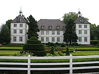
The tag historic=manor may be used for country houses once used as a ![]() manor house or
manor house or ![]() mansion or as the home of gentry/landowners.
mansion or as the home of gentry/landowners.
Distinction/conflicts
There may sometimes be problems distinguishing between manors, castles, and stately homes. The manor tag is intended for representative buildings that are or were once the administrative center of a large agricultural estate. Buildings not meeting this criteria should not be tagged as historic=manor.
How to map
Draw an area along the outline of the building. If that is infeasible, set a node at the center of the building.
Add the tag historic=manor and name=*.
Common Combinations
- building=*
- tourism=attraction
- ruins=yes
- start_date=*
- heritage=*
- wikimedia_commons=File:name - File name of a photo from Wikimedia Commons
- addr:*=*
- contact:*=*
- wikipedia=*
Example
| Photo | Tags | OSM Carto |
|---|---|---|

|
historic=manor name=Rittergut Oberzetzscha All details: 204118308 |
Today's situation
The current usage may differ from the historic usage. Draw additional node(s) ![]() and add tags for these features:
and add tags for these features:
See also
- historic=castle + castle_type=manor - for a manor houses which are castles
- historic=castle + castle_type=stately - for a stately home (château)

