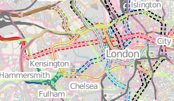
Tube Network Map
OSM tube map
Follow the above link to see a slippy rendering of the data in the OSM database planet (check the date for the last update, at the bottom of that page). This was kindly provided by Steve8.
Rendering
All railways with railway=subway have a 1 pixel line to represent them. Only zoom levels 11-14 are available. Additionally they are coloured by the standard tube line colours, and have solid colour for overground sections (tunnel=no) and dashed casings for underground sections (tunnel=yes). The server may well be slow.
Other OSM tube maps
- Transport Map in London shows tube lines, but rendered along with railways. See also Transport Map
- tube map by User:Ojw
- tube map and mashup of TfL flow data by User:Ollie
- Metrogeography distorted map is done using OSM data and Maperative.
- Old wikipedia image which is not using OSM tube data but weirdly uses very old OSM pre-mapnik display from back in 2006 (blast from the past)
Small note on licenses - PD tube station list
The "List of London Underground stations" page lists tube stations coordinates. These should also be in the OSM database. Note that the coordinates on that page were originally released to the public domain (see older version of the page), but the above linked map is rendered from the OSM database which includes other work, and possibly corrections to station positions based on Yahoo! Aerial Imagery. Therefore data in the OSM database, and the above linked map, are released with the OpenStreetMap License.
