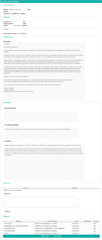
File:Autorização Dados Sobral.png
Original file (1,868 × 4,392 pixels, file size: 352 KB, MIME type: image/png)
Summary
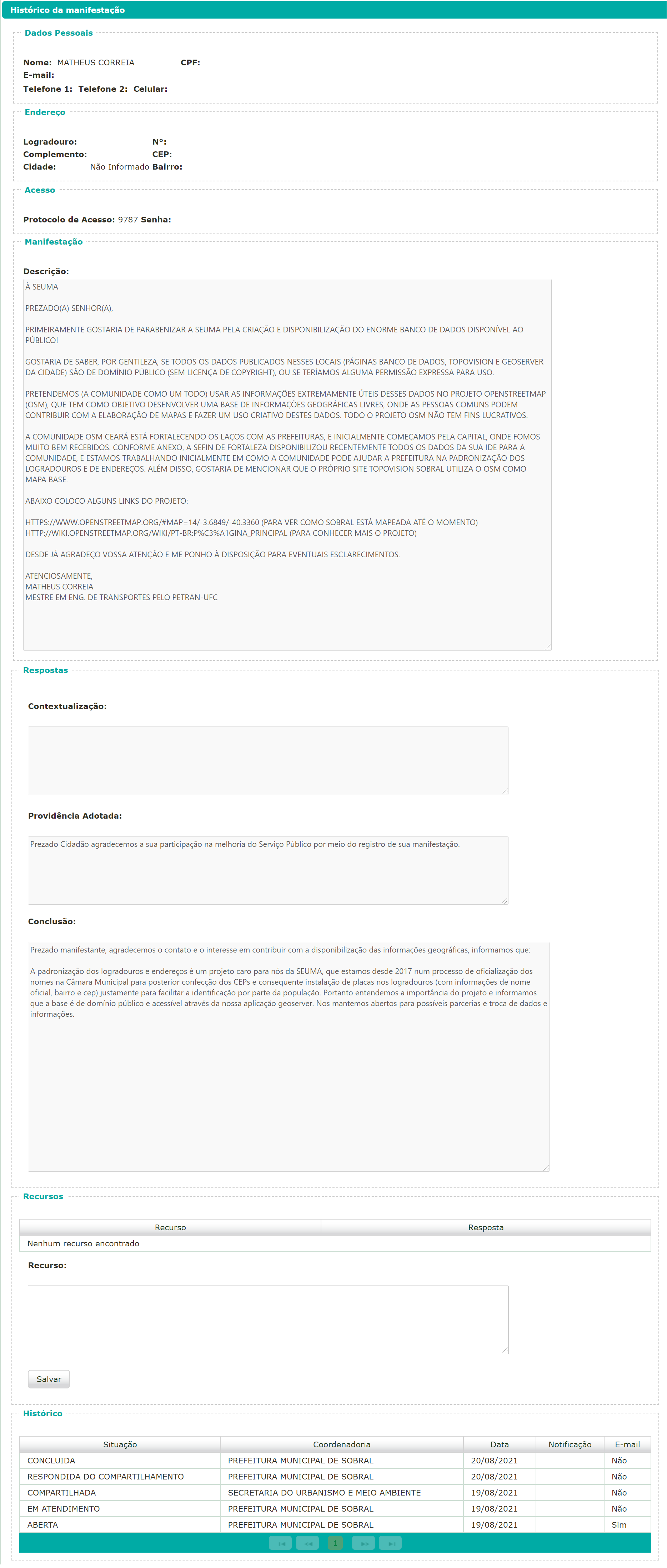
| Description | Capture of conversation between OSM user matheusgomesms and the Urbanism and Environment Secretariat (SEUMA, an agency of the Municipality of Sobral), through the Municipal Ombudsman's Office, which authorizes the use of their data in OpenStreetMap. |
|---|---|
| Author | matheusgomesms |
| Source | Own |
| Date | 2021-08-20 |
English:
Message transcript (translation):
Dear citizen, we appreciate your contact and interest in contributing to the availability of geographic information. We inform you that:
The standardization of street names and addresses is an important project for us at SEUMA, which has been in the process of making official names in the City Council since 2017 for the subsequent creation of zip codes and subsequent installation of signs in public places (with official name, neighborhood and zip code information) precisely to facilitate identification by the population. So we understand the importance of the project and inform you that the database is in the public domain and accessible through our GeoServer application. We remain open to possible partnerships and exchange of data and information.
___________________________
To SEUMA
Dear Sir or Madam,
First, I would like to congratulate SEUMA for creating and making available the huge publicly available database!
I would like to know, please, if all data published in these places (Database webpage at SEUMA, Topovision Sobral [their GIS] and GeoServer) are in the public domain (no copyright license), or if we would have any explicit permission for use.
We intend (the community as a whole) to use the extremely useful information from this data in the OpenStreetMap (OSM) project, which aims to develop a free geographic information base where ordinary people can contribute to map making and make creative use of it. of these data. The entire OSM project is not for profit.
The OSM Ceará community is strengthening ties with city halls from Ceará state, and initially we started in the state capital, where we were very well received. As attached, the Secretariat of Finances in Fortaleza recently made available all the data of its SDI to the community, and we are initially working on how the community can help the city hall in the standardization of public places and addresses. Also, I would like to mention that the Topovision Sobral website uses the OSM as its basemap.
Below I put some links to the project:
https://www.openstreetmap.org/#map=14/-3.6849/-40.3360 (to see how Sobral is mapped so far)
http://wiki.openstreetmap.org/wiki/pt-br:p%c3%a1gina_principal (to learn more about the project)
Thank you in advance for your attention and I am at your disposal for any clarifications.
Best Regards,
Matheus Correia
Português:
Captura de conversa entre usuário OSM matheusgomesms e Secretaria de Urbanismo e Meio Ambiente (SEUMA, órgão da Prefeitura Municipal de Sobral), através da Ouvidoria da Prefeitura, onde se autoriza o uso dos seus dados no OpenStreetMap.
Transcrição da mensagem:
Prezado manifestante, agradecemos o contato e o interesse em contribuir com a disponibilização das informações geográficas, informamos que:
A padronização dos logradouros e endereços é um projeto caro para nós da SEUMA, que estamos desde 2017 num processo de oficialização dos nomes na Câmara Municipal para posterior confecção dos CEPs e consequente instalação de placas nos logradouros (com informações de nome oficial, bairro e cep) justamente para facilitar a identificação por parte da população. Portanto entendemos a importância do projeto e informamos que a base é de domínio público e acessível através da nossa aplicação geoserver. Nos mantemos abertos para possíveis parcerias e troca de dados e informações.
___________________________
À SEUMA
Prezado(a) senhor(a),
Primeiramente gostaria de parabenizar a SEUMA pela criação e disponibilização do enorme banco de dados disponível ao público!
Gostaria de saber, por gentileza, se todos os dados publicados nesses locais (páginas banco de dados, Topovision e GeoServer da cidade) são de domínio público (sem licença de copyright), ou se teríamos alguma permissão expressa para uso.
Pretendemos (a comunidade como um todo) usar as informações extremamente úteis desses dados no projeto OpenStreetMap (OSM), que tem como objetivo desenvolver uma base de informações geográficas livres, onde as pessoas comuns podem contribuir com a elaboração de mapas e fazer um uso criativo destes dados. Todo o projeto OSM não tem fins lucrativos.
A comunidade OSM Ceará está fortalecendo os laços com as prefeituras, e inicialmente começamos pela capital, onde fomos muito bem recebidos. Conforme anexo, a SEFIN de Fortaleza disponibilizou recentemente todos os dados da sua ide para a comunidade, e estamos trabalhando inicialmente em como a comunidade pode ajudar a prefeitura na padronização dos logradouros e de endereços. Além disso, gostaria de mencionar que o próprio site Topovision sobral utiliza o OSM como mapa base.
Abaixo coloco alguns links do projeto:
https://www.openstreetmap.org/#map=14/-3.6849/-40.3360 (para ver como Sobral está mapeada até o momento)
http://wiki.openstreetmap.org/wiki/pt-br:p%c3%a1gina_principal (para conhecer mais o projeto)
Desde já agradeço vossa atenção e me ponho à disposição para eventuais esclarecimentos.
Atenciosamente,
Matheus Correia
Licensing
- This media file was uploaded by author of the work and its copyright holder.
![]()
![]()
The person who associated a work with this deed has dedicated the work to the public domain by waiving all of his or her rights to the work worldwide under copyright law, including all related and neighboring rights, to the extent allowed by law. You can copy, modify, distribute and perform the work, even for commercial purposes, all without asking permission.
File history
Click on a date/time to view the file as it appeared at that time.
| Date/Time | Thumbnail | Dimensions | User | Comment | |
|---|---|---|---|---|---|
| current | 15:09, 20 August 2021 | | 1,868 × 4,392 (352 KB) | Matheusgomesms (talk | contribs) | == Summary == == English: == Capture of conversation between OSM user (matheusgomesms) and the Urbanism and Environment Secretariat (SEUMA, an agency of the Municipality of Sobral), through the Municipal Ombudsman's Office, which authorizes the use of their data in OpenStreetMap. Message transcript and translated: Dear citizen, we appreciate your contact and interest in contributing to the availability of geographic information. We inform you that: The standardization of street names and... |
You cannot overwrite this file.
File usage
There are no pages that use this file.