File:Autorização IDE SEFIN Fortaleza.png
Original file (1,652 × 1,919 pixels, file size: 149 KB, MIME type: image/png)
Summary
English:
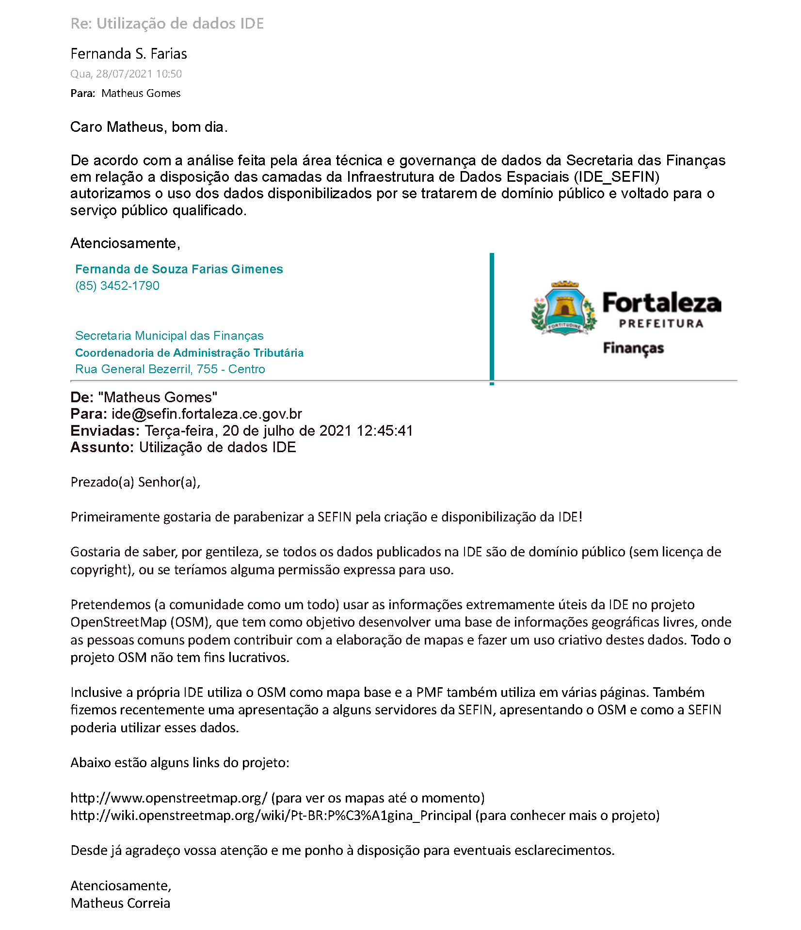
Capture of the e-mail sent by the Secretariat of Finances (SEFIN, from the Fortaleza City Council), where the use of data from the Spatial Data Infrastructure (IDE_SEFIN) platform is authorized on OpenStreetMap.
Message transcript and translated:
Wed, 07/28/2021 10:50 AM
To: Matheus Gomes
Dear Matheus, good morning.
According to the analysis made by the technical area and data governance of the Secretariat of Finances in relation to the availability of the layers of the Spatial Data Infrastructure (IDE_SEFIN), we authorize the use of the data made available because it is in the public domain and aimed at the qualified public service.
Best regards,
Fernanda de Souza Farias Gimenes
(85) 3452-1790
Secretariat of Finances of Fortaleza
Tax Administration Coordination
Rua General Bezerril, 755 - Centro
___________________________
From: "Matheus Gomes"
To: ide@sefin.fortaleza.ce.gov.br
Sent: Tuesday, July 20, 2021 12:45:41 PM
Subject: IDE Data Usage
Dear Sir or Madam,
First of all, I would like to congratulate SEFIN for the creation and availability of IDE!
I would like to know, please, if all data published in the IDE is in the public domain (no copyright license), or if we would have any express permission for use.
We intend (the community as a whole) to use the extremely useful information from the IDE in the OpenStreetMap (OSM) project, which aims to develop a free geographic information base where everyone can contribute to map making and make creative use of these data. The entire OSM project is not for profit.
Even the IDE itself uses the OSM as a base map and the Municipality of Fortaleza also uses it in several webpages. We also recently made a presentation to some SEFIN staff, introducing the OSM and how SEFIN could use this data.
Below are some project links:
http://www.openstreetmap.org/ (to see updated maps)
http://wiki.openstreetmap.org/wiki/Pt-BR:P%C3%A1gina_Principal (to learn more about the project)
Thank you in advance for your attention and I am at your disposal for any clarifications.
Best regards,
Matheus Correia
Português:
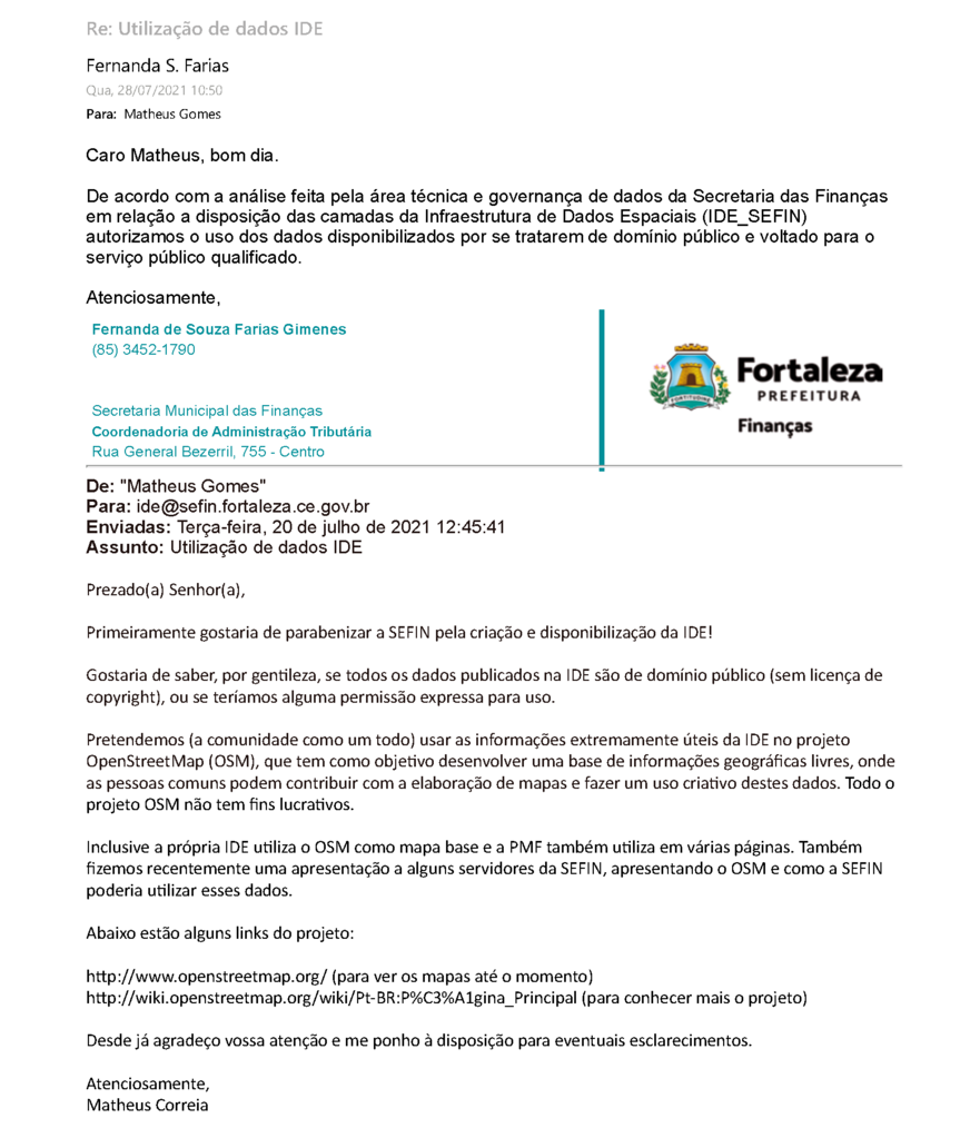
Captura da mensagem de e-mail emitido pela Secretaria Municipal das Finanças (SEINFRA, órgão da Prefeitura Municipal de Fortaleza), onde se autoriza o uso dos dados da plataforma Infraestrutura de Dados Espaciais (IDE) no OpenStreetMap.
Transcrição da mensagem:
Qua, 28/07/2021 10:50
Para: Matheus Gomes
Caro Matheus, bom dia.
De acordo com a análise feita pela área técnica e governança de dados da Secretaria das Finanças em relação a disposição das camadas da Infraestrutura de Dados Espaciais (IDE_SEFIN) autorizamos o uso dos dados disponibilizados por se tratarem de domínio público e voltado para o serviço público qualificado.
Atenciosamente,
Fernanda de Souza Farias Gimenes
(85) 3452-1790
Secretaria Municipal das Finanças
Coordenadoria de Administração Tributária
Rua General Bezerril, 755 - Centro
___________________________
De: "Matheus Gomes"
Para: ide@sefin.fortaleza.ce.gov.br
Enviadas: Terça-feira, 20 de julho de 2021 12:45:41
Assunto: Utilização de dados IDE
Prezado(a) Senhor(a),
Primeiramente gostaria de parabenizar a SEFIN pela criação e disponibilização da IDE!
Gostaria de saber, por gentileza, se todos os dados publicados na IDE são de domínio público (sem licença de copyright), ou se teríamos alguma permissão expressa para uso.
Pretendemos (a comunidade como um todo) usar as informações extremamente úteis da IDE no projeto OpenStreetMap (OSM), que tem como objetivo desenvolver uma base de informações geográficas livres, onde as pessoas comuns podem contribuir com a elaboração de mapas e fazer um uso criativo destes dados. Todo o projeto OSM não tem fins lucrativos.
Inclusive a própria IDE utiliza o OSM como mapa base e a PMF também utiliza em várias páginas. Também fizemos recentemente uma apresentação a alguns servidores da SEFIN, apresentando o OSM e como a SEFIN poderia utilizar esses dados.
Abaixo estão alguns links do projeto:
http://www.openstreetmap.org/ (para ver os mapas até o momento)
http://wiki.openstreetmap.org/wiki/Pt-BR:P%C3%A1gina_Principal (para conhecer mais o projeto)
Desde já agradeço vossa atenção e me ponho à disposição para eventuais esclarecimentos.
Atenciosamente,
Matheus Correia
File history
Click on a date/time to view the file as it appeared at that time.
| Date/Time | Thumbnail | Dimensions | User | Comment | |
|---|---|---|---|---|---|
| current | 16:44, 28 July 2021 | | 1,652 × 1,919 (149 KB) | Matheusgomesms (talk | contribs) |
You cannot overwrite this file.
File usage
There are no pages that use this file.