File:Bluefields risk places identification.jpg
Jump to navigation
Jump to search


Size of this preview: 799 × 599 pixels. Other resolutions: 320 × 240 pixels | 640 × 480 pixels | 1,024 × 768 pixels | 1,101 × 826 pixels.
Original file (1,101 × 826 pixels, file size: 198 KB, MIME type: image/jpeg)
summary
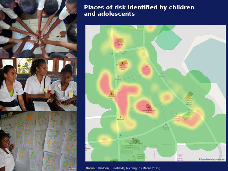
Foto series by User:Xamanu about using OSM and mapping in schools on Nicaraguas Atlantic Coast to identify places of risk and give children a voice through mapping.
https://www.flickr.com/photos/xamanu/albums/72157651536645102
Read more about the contextː Bluefields has its first collaborative map (UNICEF)
This is a Featured image, which means that it has been identified as one of the best examples of OpenStreetMap mapping, or that it provides a useful illustration of the OpenStreetMap project. If you know another image of similar quality, you can nominate it on Featured image proposals.
Front-page image for week 31 of 2016 (1–7 Aug.).
- Image descriptions
- English : In Bluefields, Nicaragua, the local OSM community and UNICEF worked with school children to help them empower themselves through the use of maps.
- italiano : A Bluefields, Nicaragua, la comunità OSM locale e l'UNICEF hanno lavorato con i ragazzi delle scuole per aiutarli ad emanciparsi tramite l'uso delle mappe.
- русский : В городе Блуфилдс (Никарагуа) волонтёры ОСМ и ЮНИСЕФ организовали занятия со школьниками. Ребята совместно разметили окрестности и стали лучше разбираться в картах.
- 中文(简体) : 在尼加拉瓜布卢菲尔兹,在地的开放街图社群和联合国儿童基金会,帮助学校儿童透过使用地图培力自己。
- 中文(繁體) : 在尼加拉瓜布盧菲爾茲,在地的開放街圖社群和聯合國兒童基金會,幫助學校兒童透過使用地圖培力自己。
File history
Click on a date/time to view the file as it appeared at that time.
| Date/Time | Thumbnail | Dimensions | User | Comment | |
|---|---|---|---|---|---|
| current | 08:51, 20 May 2016 | | 1,101 × 826 (198 KB) | Xamanu (talk | contribs) | Foto series by User:Xamanu about using OSM and mapping in schools on Nicaraguas Atlantic Coast to identify places of risk and give children a voice through mapping. https://www.flickr.com/photos/xamanu/albums/72157651536645102 Read m... |
You cannot overwrite this file.
File usage
The following 9 pages use this file: