File:CentralChester.png

Original file (1,023 × 1,145 pixels, file size: 596 KB, MIME type: image/png)
This map and others like it, were created by OpenStreetmap contributors, and are licensed as Creative Commons CC-BY-SA 2.0 (https://creativecommons.org/licenses/by-sa/2.0/) (see OpenStreetMap licence).
Use {{mapof|PlaceName}} to add this template to your images.
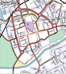
Map of Chester rendered in August 2006. This was a notable early example of rendered OpenStreetMap data from very early in the History of OpenStreetMap. It inspired the creation of "featured images", and was the very first to be featured!
Created using osmarender (or more specifically a modified osmarender2 to SVG; displayed by Adobe SVG plugin for Internet Explorer; screen capture cropped and converted by Adobe Elements to PNG) it was notable at the time for including areas in the rendering style (colours showing parks, commercial and retail districts, and residential areas)

Front-page image on 02 Sep 2006
![]()
File history
Click on a date/time to view the file as it appeared at that time.
| Date/Time | Thumbnail | Dimensions | User | Comment | |
|---|---|---|---|---|---|
| current | 16:51, 29 August 2006 | | 1,023 × 1,145 (596 KB) | Chrismorl (talk | contribs) | Central Chester rendered by a modified osmarender2 to SVG; displayed by Adobe SVG plugin for Internet Explorer; screen capture cropped and converted by Adobe Elements to PNG. The street names could be improved with a little more work, but a better labelli |
You cannot overwrite this file.
File usage
The following 4 pages use this file: