File:Detail of Antiflood walls at Holešovické nábřeží in Holešovice, Prague.jpg
Jump to navigation
Jump to search


Size of this preview: 800 × 533 pixels. Other resolutions: 320 × 213 pixels | 640 × 426 pixels | 1,024 × 682 pixels | 1,280 × 852 pixels | 2,560 × 1,705 pixels | 4,000 × 2,664 pixels.
Original file (4,000 × 2,664 pixels, file size: 3.04 MB, MIME type: image/jpeg)
This file and its description are from Wikimedia Commons.
Summary
| Description |
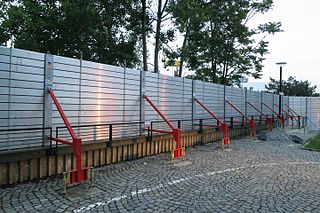
Čeština: Detail Protipovodňových zábran na Holešovickém nábřeží při pražských povodních v roce 2013 v Praze.
English: Detail of Antiflood walls at Holešovické nábřeží in Holešovice, Prague. |
| Date | |
| Source | Own work |
| Author | Jiří Sedláček |
| Camera location | | View this and other nearby images on: OpenStreetMap |
|---|
Licensing
I, the copyright holder of this work, hereby publish it under the following license:
This file is licensed under the Creative Commons Attribution-Share Alike 4.0 International license.
- You are free:
- to share – to copy, distribute and transmit the work
- to remix – to adapt the work
- Under the following conditions:
- attribution – You must give appropriate credit, provide a link to the license, and indicate if changes were made. You may do so in any reasonable manner, but not in any way that suggests the licensor endorses you or your use.
- share alike – If you remix, transform, or build upon the material, you must distribute your contributions under the same or compatible license as the original.
File history
Click on a date/time to view the file as it appeared at that time.
| Date/Time | Thumbnail | Dimensions | User | Comment | |
|---|---|---|---|---|---|
| current | 14:27, 28 January 2017 | | 4,000 × 2,664 (3.04 MB) | wikimediacommons>Frettie | User created page with UploadWizard |
File usage
The following 2 pages use this file: