File:Domínio Fortaleza em Mapas.jpg
Original file (913 × 431 pixels, file size: 55 KB, MIME type: image/jpeg)
Summary
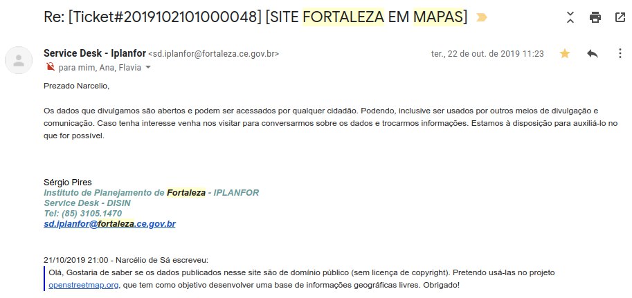
| Description | Capture of the e-mail sent by the Fortaleza Planning Institute (Iplanfor, from the Fortaleza City Council), where the use of data from the Fortaleza in Maps platform is authorized on OpenStreetMap. |
|---|---|
| Author | narceliodesa |
| Source | Own |
| Date | 2019-10-22 |
English:
Message transcript and translated:
October 22, 2019 11:23 AM
Dear Narcelio,
The data we disclose is open and can be accessed by any citizen. They may even be used by other means of dissemination and communication. If you are interested, come and visit us to talk about the data and exchange information. We are available to assist you in any way possible.
Sérgio Pires
Fortaleza Planning Institute - IPLANFOR
Service Desk - DISIN
Tel: (85) 3105.1470
sd.iplanfor@fortaleza.ce.gov.br
October 21, 2019 9:00 PM - Narcélio de Sá wrote:
Hello, I would like to know if the data published on this site are in the public domain (without copyright license). I intend to use them in the openstreetmap.org project, which aims to develop a free geographic information base.
Thank you!
Português:
Captura da mensagem de e-mail emitido pelo Instituto de Planejamento de Fortaleza (Iplanfor, órgão da Prefeitura Municipal de Fortaleza), onde se autoriza o uso dos dados da plataforma Fortaleza em Mapas no OpenStreetMap.
Transcrição da mensagem:
22 de outubro de 2019 11:23
Prezado Narcelio,
Os dados que divulgamos são abertos e podem ser acessados por qualquer cidadão. Podendo, inclusive ser usados por outros meios de divulgação e comunicação. Caso tenha interesse venha nos visitar para conversarmos sobre os dados e trocarmos informações. Estamos à disposição para auxiliá-lo no que for possível.
Sérgio Pires
Instituto de Planejamento de Fortaleza - IPLANFOR
Service Desk - DISIN
Tel: (85) 3105.1470
sd.iplanfor@fortaleza.ce.gov.br
21/10/2019 21:00 - Narcélio de Sá escreveu:
Olá, Gostaria de saber se os dados publicados nesse site são de domínio público (sem licença de copyright). Pretendo usá-las no projeto openstreetmap.org, que tem como objetivo desenvolver uma base de informações geográficas livres.
Obrigado!
Licensing
- This media file was uploaded by author of the work and its copyright holder.
![]()
![]()
The person who associated a work with this deed has dedicated the work to the public domain by waiving all of his or her rights to the work worldwide under copyright law, including all related and neighboring rights, to the extent allowed by law. You can copy, modify, distribute and perform the work, even for commercial purposes, all without asking permission.
File history
Click on a date/time to view the file as it appeared at that time.
| Date/Time | Thumbnail | Dimensions | User | Comment | |
|---|---|---|---|---|---|
| current | 15:29, 29 April 2020 | | 913 × 431 (55 KB) | Matheusgomesms (talk | contribs) | English: Capture of the e-mail message sent by the Planning Institute of Fortaleza (Iplanfor, an organ of the Municipality of Fortaleza), where the use of data from the Fortaleza platform in Maps is authorized on OpenStreetMap. Message transcript and translated: October 22, 2019 11:23 AM Dear Narcelio, The data we disclose is open and can be accessed by any citizen. They may even be used by other means of dissemination and communication. If you are interested, come and visit us to talk ab... |
You cannot overwrite this file.
File usage
There are no pages that use this file.