File:Freitals Stadtpläne.jpg
Jump to navigation
Jump to search


Size of this preview: 600 × 600 pixels. Other resolutions: 240 × 240 pixels | 480 × 480 pixels | 768 × 768 pixels | 1,024 × 1,024 pixels | 2,048 × 2,048 pixels | 5,120 × 5,120 pixels.
Original file (5,120 × 5,120 pixels, file size: 1.69 MB, MIME type: image/jpeg)
Summary
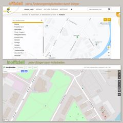
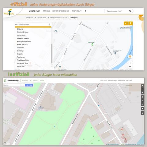
Vergleich der Satdtpläne und Mitarbeit der Bürger
Licensing
| Contains map data © OpenStreetMap contributors, made available under the terms of the Open Database License (ODbL).
The ODbL does not require any particular license for maps produced from ODbL data, produced maps may be subject also to other licences. |
File history
Click on a date/time to view the file as it appeared at that time.
| Date/Time | Thumbnail | Dimensions | User | Comment | |
|---|---|---|---|---|---|
| current | 15:04, 2 July 2020 | | 5,120 × 5,120 (1.69 MB) | Geri-oc (talk | contribs) | Vergleich der Satdtpläne und Mitarbeit der Bürger |
You cannot overwrite this file.
File usage
There are no pages that use this file.