File:Gardens of Ludwigsburg Palace.png
Jump to navigation
Jump to search


Size of this preview: 800 × 532 pixels. Other resolutions: 320 × 213 pixels | 640 × 425 pixels | 1,024 × 681 pixels | 1,264 × 840 pixels.
Original file (1,264 × 840 pixels, file size: 358 KB, MIME type: image/png)
Summary
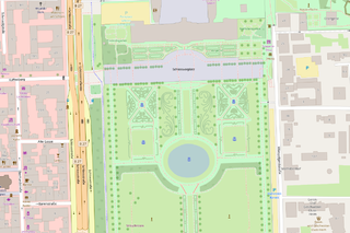
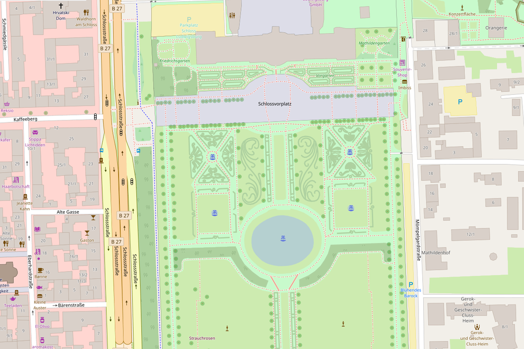
The gardens of Ludwigsburg Palace, Germany: map rendered on OpenStreetmap.
This is a Featured image, which means that it has been identified as one of the best examples of OpenStreetMap mapping, or that it provides a useful illustration of the OpenStreetMap project. If you know another image of similar quality, you can nominate it on Featured image proposals.
Front-page image for week 22 of 2017 (29 May – 4 Jun.).
- Image descriptions
- English : Nammala from the Mapbox data team gave a round-up of some recent interesting edits, mostly vandalism detected using osmcha, but also this very detailed mapping of the Gardens of Ludwigsburg Palace made by Paddy1984.
- français : Nammala, membre de l’équipe en charge des données chez Mapbox, a fait le tour de quelques récentes modifications intéressantes, notamment du vandalisme détecté avec l'outil osmcha, mais également cette carte très détaillée des jardins du palais de Ludwigsburg réalisée par Paddy1984.
- italiano : Nammala del Mapbox data team fatto un riepilogo di modifiche recenti interessanti, principalmente vandalismi individuati usando osmcha, ma anche questa mappatura dettagliata dei giardini del castello di Ludwigsburg fatta da Paddy1984.
- 中文(简体) : Mapbox 资料团队的 Nammala 记录最近一些有趣的编辑,大部分是 osmcha 侦测到的破坏,但也有 Paddy1984 绘制相当详尽的路德维希堡宫花园。
- 中文(繁體) : Mapbox 資料團隊的 Nammala 記錄最近一些有趣的編輯,大部分是 osmcha 偵測到的破壞,但也有 Paddy1984 繪製相當詳盡的路德維希堡宮花園。
Licensing
![]()
![]()
This screenshot contains OpenStreetMap Carto rendering.
The OpenStreetMap Carto map style is made available under the Creative Commons CC-0 1.0 Universal Public Domain Dedication.
- Attribution to the map data:
| Contains map data © OpenStreetMap contributors, made available under the terms of the Open Database License (ODbL).
The ODbL does not require any particular license for maps produced from ODbL data, produced maps may be subject also to other licences. |
File history
Click on a date/time to view the file as it appeared at that time.
| Date/Time | Thumbnail | Dimensions | User | Comment | |
|---|---|---|---|---|---|
| current | 00:33, 19 July 2017 | | 1,264 × 840 (358 KB) | Verdy p (talk | contribs) | enhanced version with higher resolution and more recent updates on OSM (including correction of errors in some buildings) |
| 19:41, 29 May 2017 | 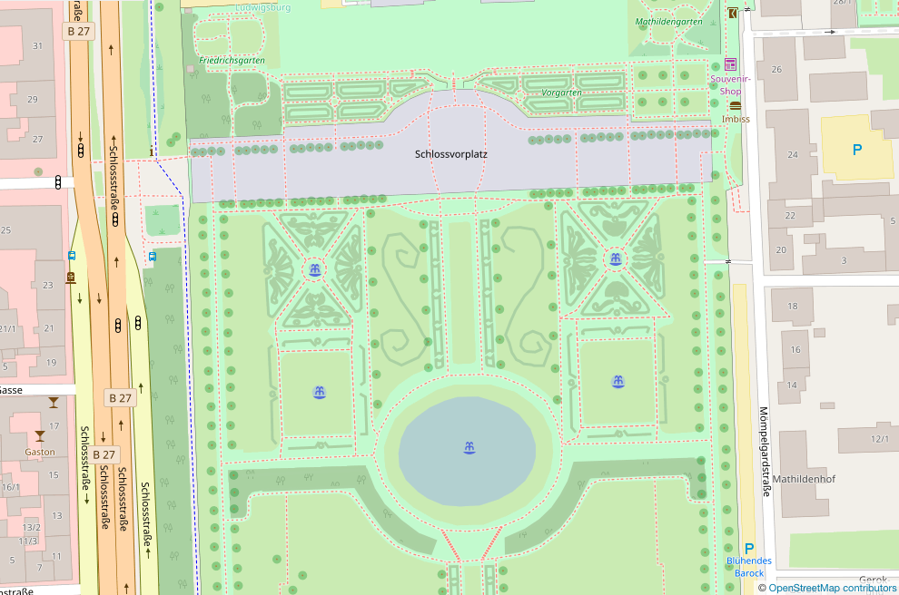 | 990 × 656 (339 KB) | Harry Wood (talk | contribs) | screenshot of http://www.openstreetmap.org/#map=18/48.89835/9.19618 |
You cannot overwrite this file.
File usage
The following 14 pages use this file:
- Featured images/Apr-Jun 2017
- List of featured images/2017
- Pt:Featured images/Apr-Jun 2017
- Uk:Featured images/Apr-Jun 2017
- Zh-hans:Featured images/Apr-Jun 2017
- Zh-hant:Featured images/Apr-Jun 2017
- Template:Featured image d2
- Template:Iotw image/2017-22
- DE:Featured images/Apr-Jun 2017
- FR:Featured images/Apr-Jun 2017
- ES:Imágenes destacadas/Abr-Jun 2017
- IT:Featured images/Apr-Jun 2017
- RU:Featured images/Apr-Jun 2017
- JA:Featured images/Apr-Jun 2017