File:Humanitarian style.png
Humanitarian_style.png (500 × 430 pixels, file size: 129 KB, MIME type: image/png)
Summary
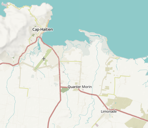
Sample of the new "Humanitarian" style Humanitarian OpenStreetMap Team

Front-page image for week 40 of 2013 (30 Sep. – 6 Oct.).
- Image descriptions
- Deutsch : Der neue „Humanitarian“-Kartenstil (auch verfügbar auf osm.org) bietet eine neue Sicht auf die OpenStreetMap-Daten (Englisch). Er zeigt das, was bei der HOT-Arbeit wichtig ist: beispielsweise Brunnen, Entsorgung, Straßenqualität, Hydranten, Elektrizitätsnetz, Straßenbeleuchtung und soziale Einrichtungen.
- English : The new "Humanitarian" style (also available on osm.org) offers a new window on OpenStreetMap data. This new style focuses on the needs of the HOT work, for example water and sanitation, road quality, fire hydrants, electricity network, street lights, or social facilities.
- español : El nuevo estilo "Humanitario" (disponible en osm.org) proporciona una nueva ventana de datos en OpenStreetMap. Mostrando las necesidades de trabajo HOT algunos ejemplos: agua y saneamiento, calidad en las carreteras, toma de agua para los bomberos, red eléctrica, alumbrado público y servicios sociales.
- italiano : Il nuovo stile "Humanitarian" (disponibile anche su osm.org) offre una nuova visuale dei dati di OpenStreetMap. Questo nuovo stile si concentra sulle necessità del lavoro di HOT, per esempio acqua e depurazione, qualità delle strade, idranti antincendio, rete elettrica, illuminazione stradale o strutture per la comunità.
- Nederlands : De nieuwe "humanitaire" kaartstijl (ook beschikbaar op osm.org) opent een nieuw venster op de OpenStreetMap data. Deze nieuwe stijl focust op de noden van het werk van HOT, zoals bijvoorbeeld water en sanitair, de kwaliteit van de wegen, brandkranen, het elektriciteitsnetwerk, straatverlichting en sociale faciliteiten.
- Türkçe : Yeni "İnsancıl" stili (Ayrıca osm.org üzerinde de mevcut), OpenStreetMap verisi üzerinde yeni bir pencere(site İngilizce'dir) açıyor. Bu stil İnsancıl OpenStreetMap takımı(İngilizce) çalışmasının üzerine odaklanıyor: Örneğin, su, yol kalıtesi, yangın söndürücüler, elektrik ağı, sokak aydınlatması, sosyal tesisler.
- русский : Новый «гуманитарный» стиль карты позволяет взглянуть на данные ОСМ под новым углом. Его дизайн разработан для использования в чрезвычайных ситуациях, где приоритет имеют расположение инфраструктуры водоснабжения, пожарных гидрантов и социально значимых объектов, качество дорог, состояние электросетей и так далее (см. статью про HOT).
- 中文(简体) : 新的"人道救援地图"样式(同时也在osm.org 呈现)能够给予检视-29_a_new_window_on_openstreetmap_data 开放街图图资的另一面。这个新的地图样式着重在HOT相关的工作,像是饮水与卫生设施,道路品质、消防栓、电力网路、路灯,或者社会福利机构。
- 中文(繁體) : 新的"人道救援地圖"樣式 (同時也在 osm.org 呈現)能夠給予檢視開放街圖圖資的另一面。這個新的地圖樣式著重在HOT相關的工作,像是飲水與衛生設施,道路品質、消防栓、電力網路、路燈,或者社會福利機構。
Licensing
![]()
(Can someone dig out the rendering's license? I could not find one. --Aseerel4c26 (talk) 22:26, 14 October 2013 (UTC) Some bits at http://hot.openstreetmap.org/updates/2013-09-29_a_new_window_on_openstreetmap_data --Aseerel4c26 (talk) 14:26, 11 November 2013 (UTC))
| Contains map data © OpenStreetMap contributors, made available under the terms of the Open Database License (ODbL).
The ODbL does not require any particular license for maps produced from ODbL data, produced maps may be subject also to other licences. |
File history
Click on a date/time to view the file as it appeared at that time.
| Date/Time | Thumbnail | Dimensions | User | Comment | |
|---|---|---|---|---|---|
| current | 10:04, 30 September 2013 | | 500 × 430 (129 KB) | Harry Wood (talk | contribs) | Sample of the new "Humanitarian" style Humanitarian OpenStreetMap Team [http://www.openstreetmap.org/#map=12/19.6932/-72.0837&layers=H here on the map] |
You cannot overwrite this file.
File usage
The following 13 pages use this file: