File:LanguageMap-Lingala-Larger Location.png
Jump to navigation
Jump to search
No higher resolution available.
LanguageMap-Lingala-Larger_Location.png (388 × 341 pixels, file size: 13 KB, MIME type: image/png)
This file and its description are from Wikimedia Commons.

|
This linguistic map image could be re-created using vector graphics as an SVG file. This has several advantages; see Commons:Media for cleanup for more information. If an SVG form of this image is available, please upload it and afterwards replace this template with
{{vector version available|new image name}}.
It is recommended to name the SVG file “LanguageMap-Lingala-Larger Location.svg”—then the template Vector version available (or Vva) does not need the new image name parameter. |
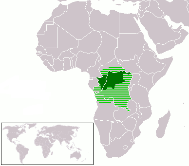
- Dark Green: Lingala native speakers
- Light Green: Area where Lingala is sometimes used
| I, the copyright holder of this work, release this work into the public domain. This applies worldwide. In some countries this may not be legally possible; if so: I grant anyone the right to use this work for any purpose, without any conditions, unless such conditions are required by law. |
File history
Click on a date/time to view the file as it appeared at that time.
| Date/Time | Thumbnail | Dimensions | User | Comment | |
|---|---|---|---|---|---|
| current | 19:38, 8 March 2018 | | 388 × 341 (13 KB) | wikimediacommons>Maphobbyist | Check |
File usage
The following page uses this file: