File:Mapping party in Low Tatras 2013-10-13 traces.png
Mapping_party_in_Low_Tatras_2013-10-13_traces.png (640 × 480 pixels, file size: 583 KB, MIME type: image/png)
Summary
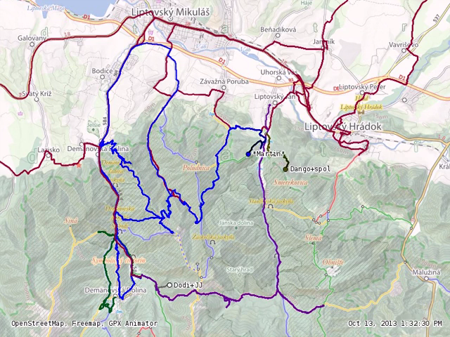
GPS traces of hiking trails recorded during a mapping party in Low Tatras (Slovakia), 12th and 13th October 2013 overlaid on the OSM-based freemap.sk hiking map. Shown here: traces as of 13th 1:32:30 PM; the three at that time actively recorded traces are marked with a dot and the mappers' names (*Martin*, Dango+spol, Dodi+JJ). View the image's area on freemap.sk or on osm.org.
Also see the video which shows a time-lapse animation of the traces.

Front-page image for week 44 of 2013 (28 Oct. – 3 Nov.).
- Image descriptions
- Deutsch : Am 12. und 13. Oktober 2013 fand eine Mapping Party in der Niederen Tatra (Slowakei) statt, deren Hauptziel es war, bisher fehlende Wander- und Radwege den OSM-Daten hinzuzufügen. Das Video zeigt eine Zeitrafferanimation der von den Teilnehmern aufgezeichneten GPS-Spuren.
- English : A mapping party in Low Tatras (Slovakia) took place on 12th and 13th October 2013 whose main objective was to add missing hiking and bicycle trails to the OSM data. The video shows a time-lapse animation of the participants' GPS traces.
- español : Del 12 al 13 de Octubre del 2013 tomó lugar en Low Tatras (Eslovaquia) mapping party donde el objetivo principal era agregar las rutas de senderismo y ciclismo faltantes en los datos de OSM. El video muestra un lapso de tiempo de la animación con las trazas GPS de los participantes.
- italiano : Un mapping party nei Bassi Tatra (Slovacchia) si è tenuto il 12 e 13 ottobre 2013 con l'obiettivo principale di aggiungere ai dati OSM i percorsi escursionistici e ciclabili mancanti. Il video mostra un'animazione time-lapse delle tracce GPS dei partecipanti.
- Nederlands : Een mapping party in Low Tatras (Slowakije) die plaats vond op 12 en 13 oktober 2013. Het belangrijkste doel was het toevoegen van ontbrekende wandel- en fietspaden aan OSM. De video geeft een animatie van de GPS-tracks weer.
- slovenčina : V Nízkych Tatrách (Slovensko) sa dňa 12. a 13. októbra 2013 konala mapping párty, ktorej hlavným cieľom bolo doplniť chýbajúce turistické a cyklistické trasy do OSM databázy. Video ukazuje animáciu časového priebehu GPS trás účastníkov.
- Türkçe : Aşağı Tatras, Slovakya'da 12-13 Ekim 2013'te yapılan haritalama partisinde ana hedef eksik yürüyüş ve bisiklet patikalarını OSM verisine eklemekti. Bu video katılımcıların GPS izlerinin hızlandırılmış bir animasyonunu gösteriyor.
- русский : Треки с картовечеринки в горах Низкие Татрасы (Словакия), которая проходила с 12 по 13 октября. Целью мероприятия было собрать треки для отсутствующих велотропинок и дорожек, а потом загрузить эти данные в ОСМ. На видео процесса видно, как передвигался каждый участник встречи.
- 中文(简体) : 10 月 12~13 日在斯洛伐克Low Tatras 举行的图客松,主要目的是增加开放街图资料库中缺漏的登山和单车路线。 这个缩时摄影动画影片 呈现参与者的GPS 轨迹。
- 中文(繁體) : 10 月 12~13 日在斯洛伐克 Low Tatras 舉行的圖客松,主要目的是增加開放街圖資料庫中缺漏的登山和單車路線。這個縮時攝影動畫影片 呈現參與者的 GPS 軌跡。
Licensing
![]()
![]()
![]()
Attribution not specified as a parameter! THIS LICENSE ALWAYS REQUIRES ATTRIBUTION! Use {{CC-BY-SA-3.0|Attribution, typically name of author}} See Template:CC-BY-SA-3.0 for full description how this template should be used.
This image is a still image of this video by *Martin* which uses this restricted content (more details at source):
- base map: Copyright ©2013 Freemap Slovakia. Licensed as Creative Commons CC-BY-SA 2.0. Some rights reserved. Map's data: (C) OpenStreetMap contributors.
File history
Click on a date/time to view the file as it appeared at that time.
| Date/Time | Thumbnail | Dimensions | User | Comment | |
|---|---|---|---|---|---|
| current | 22:31, 22 October 2013 | | 640 × 480 (583 KB) | Aseerel4c26 (talk | contribs) | GPS traces of a mapping party in Low Tatras, 12th and 13th October 2013 on the OSM-based Freemap map. Shown here: traces as of 13th, 1:32:30 PM. Source: still image of http://vimeo.com/77485518 |
You cannot overwrite this file.
File usage
The following 15 pages use this file:
- Ar:Recording GPS tracks
- Featured images/Oct-Dec 2013
- Ko:GPS 트랙 레코딩
- Pl:Rejestrowanie śladów GPS
- Recording GPS tracks
- Tr:Beginners
- Uk:Запис GPS-треків
- Template:Iotw image/2013-44
- DE:Featured images/Oct-Dec 2013
- FR:Featured images/Oct-Dec 2013
- ES:Grabación de pistas GPS
- IT:Featured images/Oct-Dec 2013
- IT:Recording GPS tracks
- NL:Recording GPS tracks
- JA:GPSトラックの記録