File:OpenSeaMap-Warnemünde.png
Jump to navigation
Jump to search


Size of this preview: 800 × 464 pixels. Other resolutions: 320 × 186 pixels | 640 × 371 pixels | 1,024 × 594 pixels | 1,280 × 742 pixels | 1,920 × 1,113 pixels.
Original file (1,920 × 1,113 pixels, file size: 785 KB, MIME type: image/png)
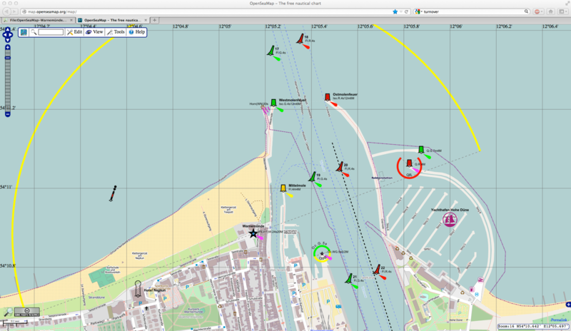
Example of Port: Warnemünde
Musterhafen "Warnemünde" Bildschirmkopie aus der Karte
| Contains map data © OpenStreetMap contributors, made available under the terms of the Open Database License (ODbL).
The ODbL does not require any particular license for maps produced from ODbL data, produced maps may be subject also to other licences. |
File history
Click on a date/time to view the file as it appeared at that time.
| Date/Time | Thumbnail | Dimensions | User | Comment | |
|---|---|---|---|---|---|
| current | 12:04, 5 December 2012 | | 1,920 × 1,113 (785 KB) | Malcolmh (talk | contribs) | |
| 22:17, 2 June 2009 |  | 1,262 × 917 (324 KB) | Markus B (talk | contribs) | Example of Port: Warnemünde Musterhafen "Warnemünde" Bildschirmkopie aus der Karte |
You cannot overwrite this file.
File usage
The following 32 pages use this file:
- Fi:OpenStreetMap:in käyttö
- Gl:Empregando OpenStreetMap
- Ko:Using OpenStreetMap
- List of OSM-based services
- Mr:Using OpenStreetMap
- OpenSeaMap
- Pl:OpenSeaMap
- Pt:List of OSM-based services
- Pt:OpenSeaMap
- Rostock
- Th:Using OpenStreetMap
- Tr:Using OpenStreetMap
- Uk:List of OSM-based services
- Using OpenStreetMap
- Zh-hans:Using OpenStreetMap
- User:Indi37
- DE:List of OSM-based services
- DE:OpenSeaMap
- DE:OpenStreetMap benutzen
- FR:OpenSeaMap
- FR:Utilisation d'OpenStreetMap
- ES:Lista de servicios basados en OSM
- ES:OpenSeaMap
- ES:Usando OpenStreetMap
- IT:OpenSeaMap
- NL:List of OSM-based services
- NL:OpenSeaMap
- NL:Using OpenStreetMap
- RU:List of OSM-based services
- RU:Использование данных OSM
- JA:OSM Online Browsing
- JA:OpenSeaMap