File:Protected Building from 1820 in Malaga 01.jpg
Jump to navigation
Jump to search


Size of this preview: 800 × 600 pixels. Other resolutions: 320 × 240 pixels | 640 × 480 pixels | 1,024 × 768 pixels | 1,280 × 960 pixels | 2,560 × 1,920 pixels | 4,000 × 3,000 pixels.
Original file (4,000 × 3,000 pixels, file size: 3.27 MB, MIME type: image/jpeg)
This file and its description are from Wikimedia Commons.
Summary
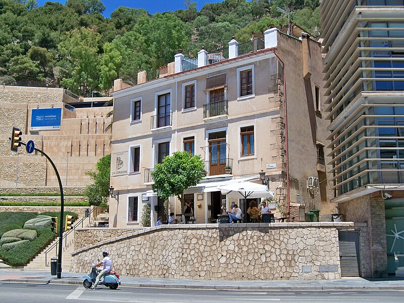
| Description |
Español: Edificio situado en el número 2 de la subida a la Coracha, Málaga, España. Se trata de un edificio de uso residencial construido en 1820, último vestigio del antiguo barrio de La Coracha, patrimonio protegido por el Ayuntamiento de Málaga desde 2021 bajo el grado I de protección arquitectónica, una figura que se fija para edificios que «por su valor, por su implantación en la estructura urbana y las posibilidades de su puesta en buen uso, deben ser protegidos, controlando las actuaciones que sobre ellos se hagan e impidiendo su desaparición o sustitución». El edificio luce una placa fechada en abril de 1970 con la siguiente inscripción: «Esta casa fue construida en 1820 y declarada conjunto histórico-artístico por decreto 12 de marzo de 1970 siendo ejemplo típico de la arquitectura malagueña del siglo XIX. Málaga Abril 1970». |
| Date | |
| Source | Own work |
| Author | Daniel Capilla |
| Other versions |
|

| Object location | | View this and other nearby images on: OpenStreetMap |
|---|
| Camera location | | View this and other nearby images on: OpenStreetMap |
|---|
Licensing
Daniel Capilla, the copyright holder of this work, hereby publishes it under the following license:
This file is licensed under the Creative Commons Attribution-Share Alike 4.0 International license.
Attribution: Daniel Capilla
- You are free:
- to share – to copy, distribute and transmit the work
- to remix – to adapt the work
- Under the following conditions:
- attribution – You must give appropriate credit, provide a link to the license, and indicate if changes were made. You may do so in any reasonable manner, but not in any way that suggests the licensor endorses you or your use.
- share alike – If you remix, transform, or build upon the material, you must distribute your contributions under the same or compatible license as the original.
File history
Click on a date/time to view the file as it appeared at that time.
| Date/Time | Thumbnail | Dimensions | User | Comment | |
|---|---|---|---|---|---|
| current | 16:13, 6 June 2022 | | 4,000 × 3,000 (3.27 MB) | wikimediacommons>Dcapillae | Uploaded own work with UploadWizard |
File usage
The following page uses this file: