File:Scotland.police.uk.png
Jump to navigation
Jump to search


Size of this preview: 800 × 540 pixels. Other resolutions: 320 × 216 pixels | 640 × 432 pixels | 1,006 × 679 pixels.
Original file (1,006 × 679 pixels, file size: 470 KB, MIME type: image/png)
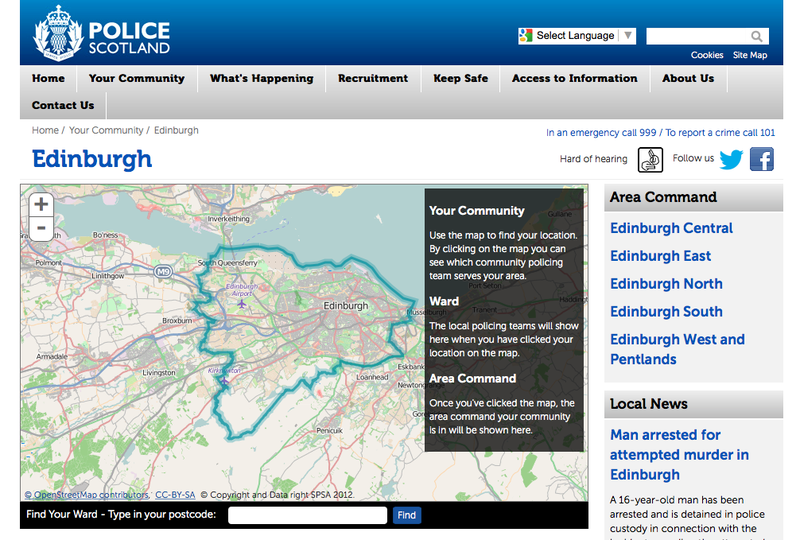
Screenshot of http://www.scotland.police.uk/your-community/edinburgh/
This is a Featured image, which means that it has been identified as one of the best examples of OpenStreetMap mapping, or that it provides a useful illustration of the OpenStreetMap project. If you know another image of similar quality, you can nominate it on Featured image proposals.
Front-page image for week 17 of 2015 (20–26 Apr.).
- Image descriptions
- Bahasa Indonesia : Polisi Skotlandia situs mereka menggunakan peta kami menunjukkan daerah penanganan polisi, seperti Edinburgh daerah.
- English : The Scottish police use our maps to display different policing regions on their website, such as this Edinburgh region
- italiano : La polizia scozzese usa le nostre mappe per visualizzare i vari distretti di polizia sul loro sito web; qui si vede il distretto di Edimburgo
- русский : Шотландская полиция использует ОСМ для отображения границ полицейских округов, например, Эдинбургского.
- 中文(简体) : 苏格兰警方在他们网站采用我们的地图显示警勤区,像是爱丁堡地区。
- 中文(繁體) : 蘇格蘭警方在他們網站採用我們的地圖顯示警勤區,像是愛丁堡地區。
File history
Click on a date/time to view the file as it appeared at that time.
| Date/Time | Thumbnail | Dimensions | User | Comment | |
|---|---|---|---|---|---|
| current | 10:11, 20 April 2015 | | 1,006 × 679 (470 KB) | Harry Wood (talk | contribs) | Screenshot of http://www.scotland.police.uk/your-community/edinburgh/ |
You cannot overwrite this file.
File usage
The following 6 pages use this file: