File:Sharif-map.png
Jump to navigation
Jump to search


Size of this preview: 599 × 600 pixels. Other resolutions: 240 × 240 pixels | 479 × 480 pixels | 757 × 758 pixels.
Original file (757 × 758 pixels, file size: 184 KB, MIME type: image/png)
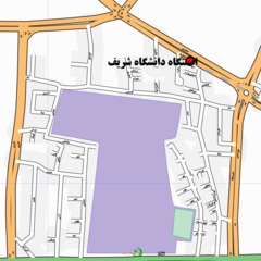
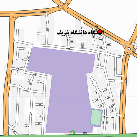
Map of the area around Sharif University of Technology in Tehran, drawn using osmarenderer using the Persian names of ways and points of interest
The map was rendered using osmarender4+lines2curves, using the following changes to the standard.xml rule file:
- "
name:fa" tags were used instead of "name" tags - The CSS style for
railway-station-captionwas slightly changed to remove "stroke: white;" - The FarsiWeb Persian fonts were installed on the machine
Map of Tehran
This map and others like it, were created by OpenStreetmap contributors, and are licensed as Creative Commons CC-BY-SA 2.0 (https://creativecommons.org/licenses/by-sa/2.0/) (see OpenStreetMap licence).
Use {{mapof|PlaceName}} to add this template to your images.
This map and others like it, were created by OpenStreetmap contributors, and are licensed as Creative Commons CC-BY-SA 2.0 (https://creativecommons.org/licenses/by-sa/2.0/) (see OpenStreetMap licence).
Use {{mapof|PlaceName}} to add this template to your images.
This is a Featured image, which means that it has been identified as one of the best examples of OpenStreetMap mapping, or that it provides a useful illustration of the OpenStreetMap project. If you know another image of similar quality, you can nominate it on Featured image proposals.
Front-page image on 10 Mar 2007
![]()
Contains map data © OpenStreetMap contributors, made available under the terms of the Creative Commons Attribution-ShareAlike 2.0 (CC-BY-SA-2.0).
![]()
It has been proposed that this page be deleted or replaced by a redirect. See the discussion page for further information.
The given reason is: After https://commons.wikimedia.org/wiki/File:Sharif-University-of-Technology-map.png contains all info listed here, apply {{Superseded by Commons|File:Sharif-University-of-Technology-map.png}} .
The given reason is: After https://commons.wikimedia.org/wiki/File:Sharif-University-of-Technology-map.png contains all info listed here, apply {{Superseded by Commons|File:Sharif-University-of-Technology-map.png}} .
File history
Click on a date/time to view the file as it appeared at that time.
| Date/Time | Thumbnail | Dimensions | User | Comment | |
|---|---|---|---|---|---|
| current | 16:02, 8 March 2007 | | 757 × 758 (184 KB) | Roozbeh (talk | contribs) | Map of the area around wikipedia:Sharif University of Technology in Tehran, drawn using osmarenderer using the Persian names of ways and points of interest |
You cannot overwrite this file.
File usage
The following file is a duplicate of this file (more details):
- File:Sharif-University-of-Technology-map.png from Wikimedia Commons
The following 3 pages use this file: