File:Tischtuch2014.png
Jump to navigation
Jump to search

Size of this preview: 800 × 536 pixels. Other resolutions: 320 × 214 pixels | 640 × 429 pixels | 1,024 × 686 pixels | 1,280 × 857 pixels | 1,551 × 1,039 pixels.
Original file (1,551 × 1,039 pixels, file size: 1.37 MB, MIME type: image/png)
Summary
German
Tischtuch mit Schwarzplan Wien (Ausschnitt Innere Stadt und Innere Bezirke), 300x200cm Layout Entwurf ScubbX, 2014-04-13
Wird in AT regelmäßig bei Veranstaltungen wie Linuxwochen und AGIT verwendet.
English
Tablecloth with building plan of Vienna, 300x200cm Layout by ScubbX, 2014-04-13
Used at Linuxwochen und AGIT.
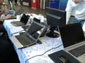
Detail, Linuxwochen 2014
Detail, Linuxwochen 2014

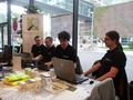
OSM Stand, AGIT 2015

OSM Stand, AGIT 2015

Detail with cap, Linuxwochen 2014
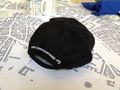
Detail with cap, Linuxwochen 2014


Licensing
![]()
![]()
![]()
This work is licensed under the Creative Commons Attribution-ShareAlike 2.0 License.
Attribution not specified as a parameter! THIS LICENSE ALWAYS REQUIRES ATTRIBUTION! Use {{CC-BY-SA-2.0|Attribution, typically name of author}} See Template:CC-BY-SA-2.0 for full description how this template should be used.
Note, there is
There is also
Attribution not specified as a parameter! THIS LICENSE ALWAYS REQUIRES ATTRIBUTION! Use {{CC-BY-SA-2.0|Attribution, typically name of author}} See Template:CC-BY-SA-2.0 for full description how this template should be used.
Note, there is
{{CC-BY-SA-2.0 OpenStreetMap}} for files based on old OSM map data, before the license change made on 2012-09-12.There is also
{{OSM Carto screenshot||old_license}} for files based on old OSM map data, before the license change made on 2012-09-12, created using OSM Carto map style.
File history
Click on a date/time to view the file as it appeared at that time.
| Date/Time | Thumbnail | Dimensions | User | Comment | |
|---|---|---|---|---|---|
| current | 09:31, 8 July 2015 | | 1,551 × 1,039 (1.37 MB) | Al. (talk | contribs) | Tischtuch mit Schwarzplan Wien (Ausschnitt Innere Stadt und Innere Bezirke), Layout Entwurf ScubbX, 2014-04-13 |
You cannot overwrite this file.
File usage
The following 3 pages use this file: