File:Turkmenabat-new-lands.jpg
Jump to navigation
Jump to search


Size of this preview: 800 × 571 pixels. Other resolutions: 320 × 229 pixels | 640 × 457 pixels | 1,024 × 731 pixels | 1,280 × 914 pixels | 2,233 × 1,595 pixels.
Original file (2,233 × 1,595 pixels, file size: 404 KB, MIME type: image/jpeg)
Summary
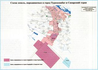
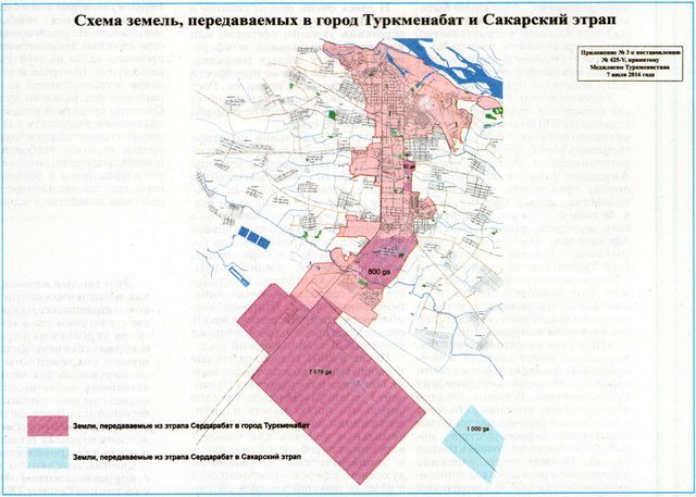
| Description | Map published in the official gazette of Turkmenistan in July 2016 depicting new territories added to the city of Turkmenabat. The large rectangle at the southern end of the city is the location of the new international airport inaugurated in February 2018. |
|---|---|
| Author | ?? |
| Source | ?? |
| Date | 2016-07-01 |
Licensing
This document is in the public domain.
Under Turkmenistan's copyright law,
Article 7. Works that are not objects of copyright
Not subject to copyright:
- official documents (laws, court decisions, other texts of a legislative, administrative and judicial nature), as well as their official translations;
- state symbols and signs (flag, coat of arms, anthem, awards, banknotes and other state symbols and signs);
- folk art (expressions of folklore); - messages about events and facts of an informational nature.''
File history
Click on a date/time to view the file as it appeared at that time.
| Date/Time | Thumbnail | Dimensions | User | Comment | |
|---|---|---|---|---|---|
| current | 15:13, 9 July 2018 | | 2,233 × 1,595 (404 KB) | Apm-wa (talk | contribs) | Map published in the official gazette of Turkmenistan in July 2016 depicting new territories added to the city of Turkmenabat. The large rectangle at the southern end of the city is the location of the new international airport inaugurated in February... |
You cannot overwrite this file.
File usage
The following page uses this file: