JGPSTrackEdit
| JGPSTrackEdit | |
|---|---|
| Author: | Hubert Lutnik |
| License: | GNU General Public License v3 |
| Platforms: | Windows, macOS, Linux, and Unix |
| Version: | 1.1.0 (2013-04-14) |
| Languages: | English and German |
| Website: | http://sourceforge.net/projects/jgpstrackedit |
| Programming language: | Java |
|
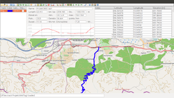
Tool for editing gps tracks and planning (multiple days) tours. | |
JGPSTrackEdit is a tool for editing gps tracks and planning (multiple days) tours (GPS track editor), a desktop application developed by Hubert Lutnik. Its homepage is located at http://sourceforge.net/projects/jgpstrackedit/ .
An abritary number of tracks may be opened or created, tracks may be merged. A track may be splitted, reversed or edited (e.g. compressed and corrected). Points may be inserted or appended to a track (routing supported) or may be moved or deleted from a track.
Maps of several providers are available, the default map is OpenStreetMap.
Currently supported track formats: garmin route, gpx and txc, kml, import from GPSies.
Usage
To run the software, a Java runtime installation is required (may be obtained from http://www.java.com/download/index.jsp)
More information, including the user manual, may be found on the wiki pages of the project.
