Key:checkpoint
| Description |
|---|
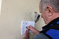
| A place where a hiker or cyclist can validate the reach of a checkpoint. |
| Group: tourism |
| Used on these elements |
| Status: approved |
| Tools for this tag |
|
This tag indicates a place where a hiker or cyclist can validate the reach of a checkpoint.
Course
A course is a permanent tour that is organised by an organisation. It can consist of one or several trails, routes, walks or only of checkpoints. An organisation can start many of these, e.g. the Hungarian Rambler's Association have more than a hundred listed on their website. You can start to complete a course by buying its brochure or registerig at their website and completing it by validating all the checkpoints by electronic means, stamping or by writing down a code. At the end you usually receive a badge or similar reward.
There are two types of courses:
- Most courses have a designated route
- For an example, see the Wikipedia page on El Camino de Santiago. On the right, you can see the stamps.
- Another example is 'The validation of the completion' section on the Wikipedia page of the Countrywide Blue Tour in Hungary.
- The individual trails on trail-blaze.com can be considered as a Hiking Course.
- There are also courses that require visiting all checkpoints in any order from any direction, like all the castles and springs of a mountain range. So there is no required route, hence the use of course to avoid confusion.
- An example on the page of the Hungarian Rambler's Association (Hungarian) is a list of hiking courses. The courses with the dotted icons are the courses with only checkpoints.
See also Walking Routes.
Tagging
Checkpoint type
| Tag | Description |
|---|---|
| checkpoint:type=stamp | A stamping point. |
| checkpoint:type=code | A code, displayed on a sign, that needs to be written down. |
| checkpoint:type=electronic | An electronic device used with a timing tag. |
| checkpoint:type=notebook | A paper based medium to sign/note, such as a notebook or guestbook. |
| Proposal: checkpoint:type=puncher | Proposal: A punching device ("hole punch") for paper/plastic/board to punch holes of different patterns, similar to stamping. |
Course
- course=* is the name of the hiking or cycling course.
Other tags
- name=* is used only to describe the place, e.g. name of the building, pub, mountain, etc.
- name:xx is used to state the name of the course in a language e.g name:en=England.
- description=* is used to describe the course, not for the name of the course.
- url=* is a url to the course and the organisation.
Examples
name=Írott-kő
checkpoint=hiking
checkpoint:type=stamp
course=Országos Kéktúra
operator=Magyar Természetbarát Szövetség
url=http://termeszetbarat.hu/turamozgalmak/orszagos_kektura
name:en=Countrywide Blue Tour
Or on a pub on El Camino:
building=yes
name=John Bull Pub
checkpoint=hiking
checkpoint:type=stamp
course=El Camino de Santiago
operator=Junta de Galicia
url=http://www.caminosantiagodecompostela.com/
name:en=Way of St. James
description=nice bar
Example on trail-blaze.com:
name=Princes Risborough
checkpoint=hiking
checkpoint:type=electronic
course=The Ridgeway
operator=trail-blaze.com
url=http://www.trail-blaze.com/race.asp?race=14
Applies to
- Nodes
- Areas (buildings)
- Relation (multipolygon buildings)
Rendering
No rendering on street maps.
On special interest maps for hikers, a stamp.
