Planet.gpx
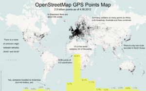
planet.gpx was a new data download offered alongside planet.osm, this time with all the GPS data OpenStreetMap holds. The latest version is now from 2013
https://planet.openstreetmap.org/gps/
This is the collected GPS point data from the first seven and a half years of OpenStreetMap. It is a very large collection of points and it is very raw data. See Upload for information on how you can add to this.
- The compressed file is 7GBytes in size
- Uncompressed, the file is a 55GByte text file
- The data consists of coordinate pairs only, with no track file or meta data
- Points were contributed by thousands of users
- Points were contributed as thousands of distinct track files
- The data includes 2,770,233,904 points
Format of simple GPS dump
-900000000,1771882380
-900000000,1293757490
-891154290,1237501070
-877697750,1653442410
-871875000,1589069750
-871875000,1237507350
-843750000,1350007780
...
These are comma separated, raw lat / lon coordinates in a simple text format. To get the coordinates divide each number by 107. The points are sorted by location, starting in the far southeast of the globe (90 S,180 E) and moving northwest.
Extracts
Regional extracts are here.
These are updated infrequently, but usually a couple of weeks behind the GPX Planet.
Visualisation
And on this map they're aggregated into hexagons
This map shows GPS density corrected for population
All points are rendered as a scatter plot on a map in 20 levels with subset download feature. Check on UCRStar
Processing
- Perl scripts that can be used to render GPX points on a map.
- Regional extract are here.
- JAVA application that can be used to extract GPX points from the GPS planet file(s) and to export to ESRI 3D Shape Format (works also with the regional extracts), (related blog posts: 1,2,3,4)
- JAVA application that can be used to match the GPS traces to the OSM street network, (cf.: blog of post university of Heidelberg)
