Uploads by Carto'Cité
Jump to navigation
Jump to search
This special page shows all uploaded files.
| Date | Name | Thumbnail | Size | Description | Versions |
|---|---|---|---|---|---|
| 13:02, 28 November 2023 | 20231111 - Centimeter geolocation at low cost with Centipede RTK.pdf (file) |  |
7.58 MB | {{Information | description=Slides for the SOTM-EU talk "Centipede RTK - Centimer geolocation at low cost" | source= | date=2023-11-11 | author=Antoine Riche | other_versions= }} | 1 |
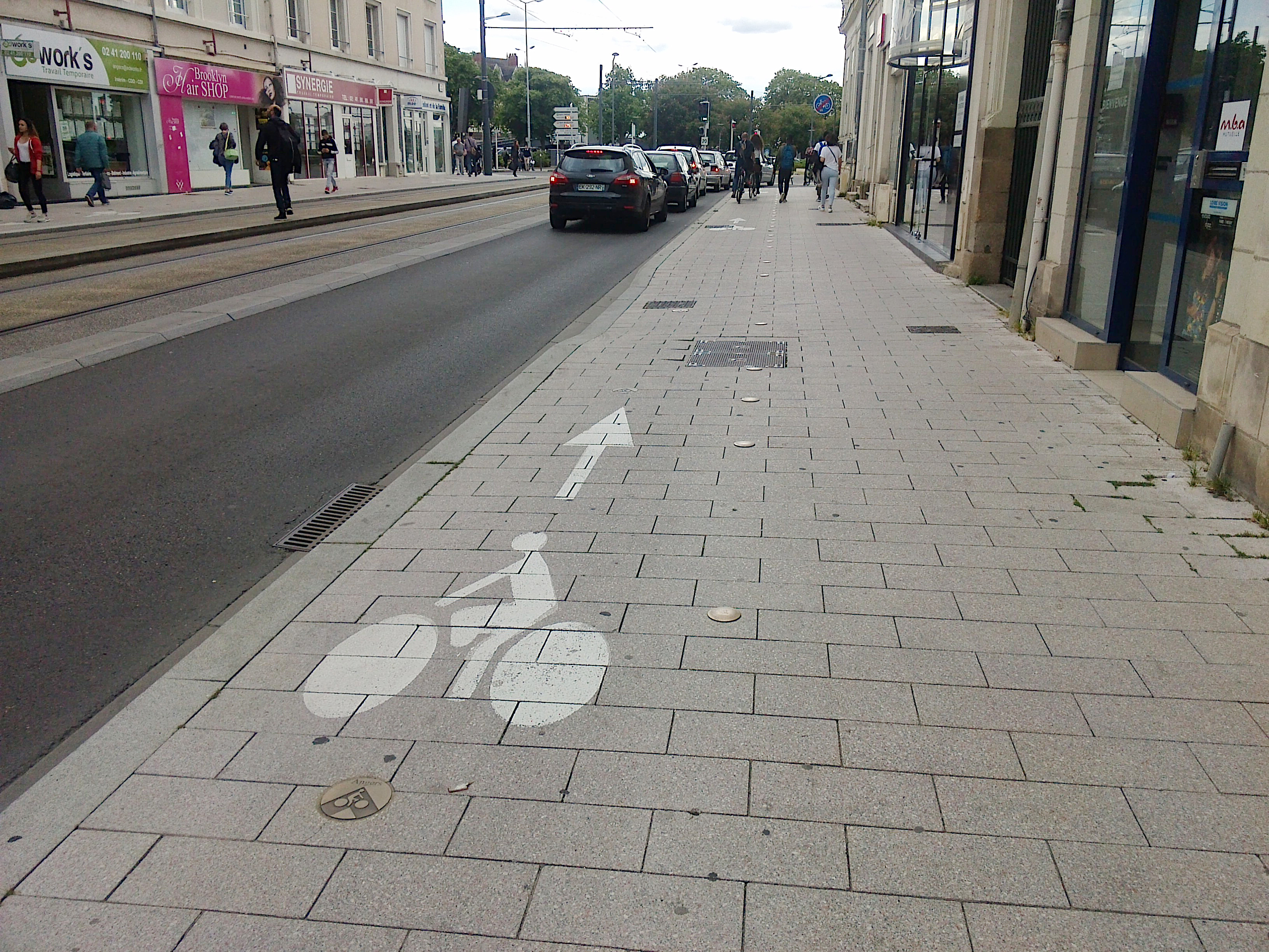
| 17:58, 9 February 2021 | Trottoir cyclable partagé – Angers.jpg (file) |  |
2.13 MB | 1 | |
| 17:54, 9 February 2021 | Cycle empower sidewalks left right segregated.svg (file) |  |
29 KB | 1 | |
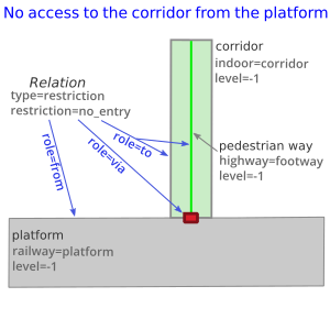
| 07:45, 9 October 2020 | Pedestrian routing restriction no entry-EN.png (file) |  |
31 KB | Applying the restriction relation to pedestrian routing. Note an SVG version is available. | 1 |
| 07:43, 9 October 2020 | Pedestrian routing restriction no entry-EN.svg (file) |  |
35 KB | Applying the restriction relation to pedestrian routing. | 1 |
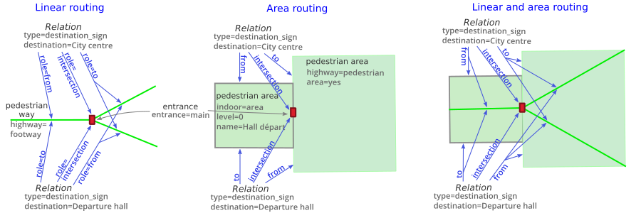
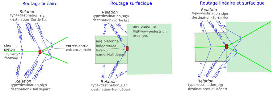
| 07:40, 9 October 2020 | Pedestrian routing destination sign-EN.svg (file) |  |
108 KB | Applying the destination_sign relation to pedestrian routing | 1 |
| 07:40, 9 October 2020 | Pedestrian routing destination sign-EN.png (file) |  |
114 KB | Applying the destination_sign relation to pedestrian routing | 1 |
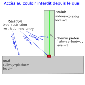
| 15:51, 9 September 2020 | Pedestrian routing restriction no entry-FR.png (file) |  |
30 KB | Applying the restriction relation to pedestrian routing. Note an SVG version is available. | 1 |
| 15:47, 9 September 2020 | Pedestrian routing destination sign-FR.png (file) |  |
114 KB | Applying the destination_sign relation to pedestrian routing Note an SVG version is available. | 1 |
| 15:45, 9 September 2020 | Pedestrian routing destination sign-FR.svg (file) |  |
108 KB | Better positioning of arrows and texts | 2 |
| 14:36, 9 September 2020 | Relation destination sign for pedestrian routing - Boulainvilliers station.jpg (file) |  |
800 KB | Two views of the same entrance at Boulainvilliers railway station (Paris, FR), where the destination sign differs depending on the direction one crosses the door. | 1 |
| 10:24, 31 August 2020 | Pedestrian routing restriction no entry-FR.svg (file) |  |
31 KB | Applying the restriction relation do pedestrian routing | 1 |
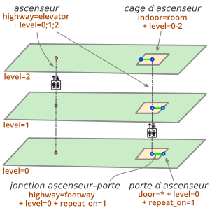
| 15:28, 6 September 2019 | Building indoor elevator-EN.svg (file) |  |
42 KB | Elevator as a single node or as a room (shaft) | 1 |
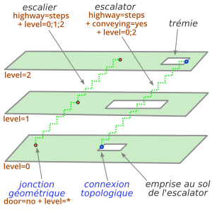
| 15:27, 6 September 2019 | Building indoor steps-EN.svg (file) |  |
33 KB | Indoor steps with topological or geometrical connections | 1 |
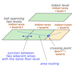
| 15:26, 6 September 2019 | Building indoor floor level-EN.svg (file) |  |
25 KB | Junction between two adjacent pedestrian areas with the same floor level. | 1 |
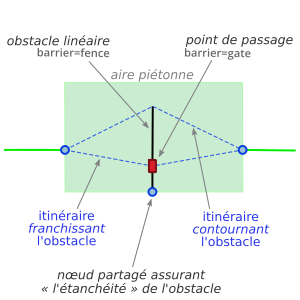
| 15:25, 6 September 2019 | Barrier and waypoint-EN.svg (file) |  |
23 KB | Pedestrian area routing – a linear barrier that can be got around or crossed through a waypoint. | 1 |
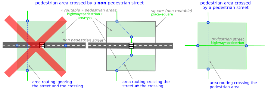
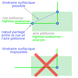
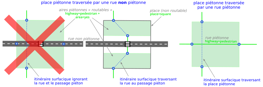
| 15:24, 6 September 2019 | Pedestrian area routing-EN.svg (file) |  |
41 KB | Mapping a pedestrian area crossed by a street | 1 |
| 15:22, 6 September 2019 | Line area connection-EN.svg (file) |  |
20 KB | Connecting a line to a polygon to enable open area routing | 1 |
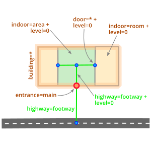
| 15:21, 6 September 2019 | Building indoor routing.svg (file) |  |
23 KB | Pedestrian routing to and inside a building | 1 |
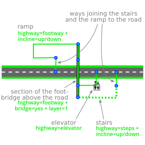
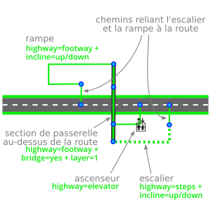
| 15:20, 6 September 2019 | Bridge steps elevator-EN.svg (file) |  |
41 KB | Pedestrian bridge crossing a road with stairs, an escalator and an inclined footway | 1 |
| 15:18, 6 September 2019 | Sidewalk connection-EN.svg (file) |  |
24 KB | Recommendation to connect a footway to a street | 1 |
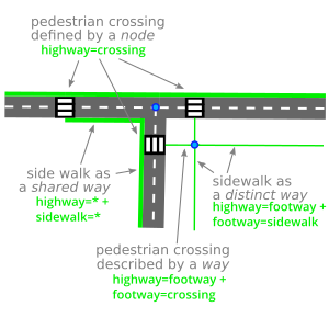
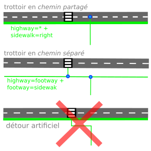
| 15:12, 6 September 2019 | Sidewalk crossing-EN.svg (file) |  |
37 KB | Shared and separate sidewalks and how to connect them at a pedestrian crossing | 1 |
| 13:47, 6 September 2019 | Building indoor elevator-EN.png (file) |  |
38 KB | Elevator as a single node or as a room (shaft) | 1 |
| 13:43, 6 September 2019 | Building indoor steps-EN.png (file) |  |
39 KB | Indoor steps with topological or geometrical connections | 1 |
| 13:32, 6 September 2019 | Building indoor floor level-EN.png (file) |  |
32 KB | Junction between tzo adjacent pedestrian areas with the same floor level | 1 |
| 13:22, 6 September 2019 | Barrier and waypoint-EN.png (file) |  |
33 KB | Pedestrian area routing – a linear barrier that can be got around or crossed through a waypoint. | 1 |
| 10:05, 6 September 2019 | Pedestrian area routing-EN.png (file) |  |
65 KB | Mapping a pedestrian area crossed by a street | 1 |
| 09:57, 6 September 2019 | Line area connection-EN.png (file) |  |
29 KB | Connecting a line to a polygon to enable open area routing | 1 |
| 09:51, 6 September 2019 | Bridge steps elevator-EN.png (file) |  |
31 KB | Pedestrian bridge crossing a road with stairs, an escalator and an inclined footway | 1 |
| 09:44, 6 September 2019 | Sidewalk crossing-EN.png (file) |  |
33 KB | Shared and separate sidewalks and how to connect them at a pedestrian crossing | 1 |
| 09:42, 6 September 2019 | Sidewalk connection-EN.png (file) |  |
20 KB | Recommendation to connect a footway to a street | 1 |
| 13:08, 26 June 2019 | Building indoor elevator-FR.png (file) |  |
39 KB | Correction door=no -> door=* | 2 |
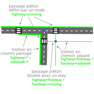
| 18:25, 25 June 2019 | Sidewalk crossing-FR.png (file) |  |
32 KB | Correction tag : footway=sidewalk et non footway=crossing | 3 |
| 09:43, 25 May 2019 | Building indoor steps-FR.png (file) |  |
39 KB | 2 | |
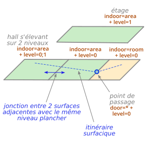
| 19:39, 24 May 2019 | Building indoor floor level-FR.png (file) |  |
34 KB | Jonction entre deux aires piétonnes adjacentes ayant le même niveau plancher | 1 |
| 08:34, 20 May 2019 | Line area connection-FR.png (file) |  |
29 KB | 2 | |
| 08:26, 20 May 2019 | Bridge steps elevator-FR.png (file) |  |
31 KB | 4 | |
| 17:12, 10 May 2019 | Steps geometry connection FR.png (file) |  |
49 KB | Ambiguous and non ambiguous geometry junctions between a line and an area | 1 |
| 08:11, 9 May 2019 | Barrier and waypoint-FR.png (file) |  |
34 KB | 2 | |
| 11:28, 8 May 2019 | Pedestrian area routing-FR.png (file) |  |
64 KB | 3 | |
| 08:35, 8 May 2019 | Topology geometry junction-FR.png (file) |  |
28 KB | Topological and geometrical junctions between a line and an area, for pedestrian routing. | 1 |
| 08:30, 8 May 2019 | Line area connection-FR.svg (file) |  |
19 KB | Connecting a line to a polygon to enable open area routing | 1 |
| 08:28, 8 May 2019 | Topology geometry junction-FR.svg (file) |  |
22 KB | Topological and geometrical junctions between a line and an area, for pedestrian routing. | 1 |
| 16:30, 6 May 2019 | Building indoor routing-FR.png (file) |  |
21 KB | Pedestrian routing to and inside a building | 1 |
| 15:07, 6 May 2019 | Sidewalk connection-FR.png (file) |  |
20 KB | 3 | |
| 16:45, 14 February 2019 | Logo Carto’Cité.svg (file) |  |
13 KB | 1 | |
| 19:53, 30 January 2019 | CartoVeloIDF ateliers carto.pdf (file) |  |
321 KB | Présentation des ateliers de cartographie au service des cyclistes : initiation à l'utilisation d'un "GPS Vélo" et signalement d'erreurs sur la carte, et recensement des parkings vélo lors d'une cartopartie. Ateliers animés par l'association MDB e... | 1 |
| 11:56, 5 July 2018 | OSMecum CartoVeloIDF avancé A4.pdf (file) |  |
355 KB | OSMécum réalisé dans le cadre du projet #CartoVeloIDF Niveau avancé : type et qualité du revêtement, matérialisation des aménagements, obstacles | 1 |
| 11:55, 5 July 2018 | OSMecum CartoVeloIDF avancé A4.odt (file) | 3.08 MB | OSMécum réalisé dans le cadre du projet #CartoVeloIDF Niveau avancé : type et qualité du revêtement, matérialisation des aménagements, obstacles | 1 | |
| 11:53, 5 July 2018 | OSMecum CartoVeloIDF moyen A4.pdf (file) |  |
119 KB | OSMécum réalisé dans le cadre du projet #CartoVeloIDF Niveau moyen : aménagements cyclables, pistes et bandes cyclables, double-sens cyclables, voies partagées etc. | 1 |