Key:level
| Description |
|---|
| Floor number of a feature. |
| Group: Placement |
| Used on these elements |
| Useful combination |
| Status: de facto |
| Tools for this tag |
|
Level indicates the floor level, can be used for ways, shops and amenities that are tied to a floor level of a multilevel building. See Simple Indoor Tagging for further information.
Highways (and other ways) can be tagged with level when they are essentially bound to a level of a building complex (such as multilevel parking buildings, railway stations or airports).
For typical street and freeway crossings with bridges, layer=* should be used instead.
Roads or other ways passing through buildings should be marked with tunnel=building_passage; they should be only marked with level if there is a strong relation to the corresponding level of the building.
Values
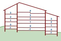
The value of the level=* is numerical and used to denote the vertical order of the floors. Usually, level=0 is the ground floor, level=1 the floor above it and basement floors start with level=-1.
Data users cannot assume that level=0 is always at street level. If the building uses a different floor numbering scheme, the floor at street level may have a different number. For example, in the United States, Russia, Japan and more countries, it is common to denote the first floor as the floor at street level.[1] However, data consumers relying on tagging standards such as Simple Indoor Tagging will expect level numbers to at least be consecutive (i.e. the level above 3 is 4, the level above -1 is 0). If that is not the case for a building, skipped_levels=* may be used on the building outline, or the levels can be tagged as level:ref=* instead (see #Level denominations).
There is also an ongoing discussion on usage of fractional values, e.g. level=0.5 or level=1.5 for mezzanine floors and staircases. See the proposals for more examples.
Level denominations
- Main article: Key:level:ref
- Main article: Key:addr:floor
When a building uses non-numeric or otherwise non-standard floor denominations, as many malls do, it is possible to tag the individual shops on a floor with level:ref=* instead of level=*, however this requires substantially more work to be compatible with SIT, see below. The simplest solution is to add both level and level:ref in such cases. For example, the Siam Paragon mall in Bangkok consists of the following floors: B,G,M,1,2,3,4,4A and 5[2]. A shop on level 4A can then be tagged with level:ref=4A .
Note that when tagging shops exclusively with level:ref=*, the information about which floor is above or below another is missing. To consolidate this information, the Simple Indoor Tagging scheme suggests creating an outline for each level, tagged with indoor=level, adding both level=* and level:ref=* to it. This also works the other way round - if only level=* is defined on the individual shops.
Multiple values
Level range: level=-1;0 room=yes is a room which goes over (spans) two levels. It's the same room that is accessible on both levels. Often there are doors to each one. If a room is repeated on multiple levels, meaning it's a different room but it looks/functions identical, draw one element for each room or use repeat_on=*.
Similarly a staircase could be tagged with level=-1;0 meaning that it connects the two levels.
See also
- layer=* - Used to mark the vertical relationship between two intersecting features, especially for bridges and tunnels at highway or railway junctions.
- building:levels=* - The number of above ground levels in a building (if there's only the ground level, this is 1), not including the levels in the roof (use roof:levels to state the number of roof levels).
- addr:floor=* - The floor an apartment/flat is located.
- repeat_on=* - For features that repeat on several levels / floors where similar copies of a feature can be found at the same position.
- tunnel=building_passage - A passage through a building, normally as an archway or overhang.
- Indoor Mapping
References
- ↑ There has been confusion about this part which has been cleared up in a mailing list discussion
- ↑ Directory of Siam Paragon on their website
