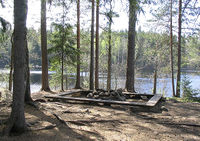
Tag:leisure=firepit
Jump to navigation
Jump to search
| Description |
|---|
| A fire ring or fire pit, often at a campsite or picnic site |
| Rendering in OSM Carto |
| Group: leisure |
| Used on these elements |
| Implies |
| Useful combination |
|
| See also |
| Status: de facto |
| Tools for this tag |
|
A permanent location or structure like a ![]() fire ring or
fire ring or ![]() fire pit, to host campfires, bonfires, or other open fires.
fire pit, to host campfires, bonfires, or other open fires.
How to map
Additional tags
- access=private / access=customers if access to this object is limited and not open to everybody
- wood_provided=yes/no to indicate whether wood is provided by the operator or not
- grate=yes/no if the firepit features a grate to cook food on
- kettle_hook=yes/no if the firepit features a kettle hook
Photos
See also
- openfire=yes e.g. related to a campsite or camp pitch
- real_fire=no – for a fireplace with an artificial fire
- tourism=picnic_site
- tourism=camp_site
- tourism=camp_pitch
- amenity=bbq – for a barbecue / bbq grill (i.e. when it has metal grill on which you place food to cook it)
- fireplace=* – for features that include a fireplace with chimney


