Ko:Tag:highway=stop
| 설명 |
|---|
| 정지 표지판을 표시할 때 사용 |
| 그룹: 도로 |
| 해당 요소의 사용 |
| 유용한 조합 |
| 같이 보기 |
| 상태:사실상 표준 |
| 이 태그를 위한 도구 |
highway=stop 태그는 차량이 멈춰야 할 필요가 있는 곳을 표시할 때 사용합니다. 멈춰야 할 필요가 있는 곳은 정지 표지판과 정지선, 그리고 (잠재적인) 법적으로 물리적 정지가 있어야 하는 곳을 포함합니다.
영어 원본의 내용을 이해할 수 있다면 번역 완료에 힘을 모아 주십시오. 번역 방법에 대해서는 위키 번역 방법에 대한 설명을 읽어주시길 바랍니다. 만약 이 문서의 번역이 충분하다고 판단되면 이 틀을 지워주시길 바랍니다.
이 즈음에는 맡아서 번역을 하는 사람이 없기 때문에, 당신이 이 작업을 해 줄 수 있습니다.
There are two common situations: (1) some approaches don't stop (minor road stop); (2) all approaches must stop (all-way stop). At cross-streets, they are called 4-way stops.
매핑 방법
There have been numerous views and proposals on how to map stop signs, and different methods have coexisted so far. If we are now to distinguish minor road stops from all-way stops, give way junctions, motorway merges and uncontrolled intersections -- in support of smartphone safety apps -- we should try to be more consistent.
Tagging minor road stops
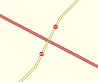
Insert a highway=stop node on the approach way(s) that must stop, at the stopping point. Drivers may be required to give way (yield) whether or not a physical sign is present; but if you also want to capture the signs, you can use a traffic_sign=* tag as well. In all-way stop countries you could also add stop=minor to distinguish 2-way from 4-way stop signs.
As this minor road highway=stop node is NOT at the intersection point, we know it just shows the stop line. The roadway approaches that do not stop will have no highway=stop nodes before the conflict point. Do NOT tag the conflict points -- the priority junction node(s)) -- with highway=stop, because not all the approaches will stop.
Since the stop line on the approach applies to only one travel direction, that direction can usually be deduced by finding the shorter distance to the priority intersection. However, a few stop signs are on 2-way streets between closely-spaced junctions, making it necessary to identify the travel direction that stops. Where needed, this can be done using direction=forward or direction=backward, relating stop direction to OSM forward/backward of the way that contains the highway=stop node.
Presently, reversing the forward direction of a segment in iD, Potlach or JOSM will break the direction tag. Be aware when editing to correct all relations as such, including the direction=* tag to amend these problems you may create. JOSM (after release 11223) gives warning on reversing ways with direction-dependent nodes and proposes the opposite value.
iD does now automatically change the direction=* tag to the opposite value if you reverse the direction of a way which includes direction-dependent nodes.
Tag the priority junction node
At major road priority junctions (which require minor roads to stop or give way), tag the intersection node(s) where traffic conflicts can occur with highway=priority, to identify the actual conflict point that is controlled by a priority rule. This will help a safety app or automated vehicle know that emerging side-road vehicles may create a hazard at that main-road junction node. Tagging the junction with highway=priority can also help eliminate directional ambiguity on the map (by identifying the actual priority intersection controlled by nearby stop or give way signs).
Tag priority road on the ways
Main road ways that do not stop can be further emphasized using priority_road=*; either (priority_road=designated or priority_road=yes_unposted). The designated value is used in countries that sign some priority roads (main roads) with a yellow diamond with a black border on a white surround.
전방향정지
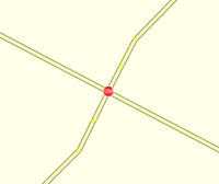
All-way stops should ALWAYS be shown using highway=stop at the intersection node. If you also want to add the individual stopping points, say for use by a safety app (so that the exact stopping points have been recorded) do NOT remove the intersection node highway=stop, which confirms that this junction is an all-way stop.
If you want to further confirm that this is an all-way stop, you can add stop=all to the intersection's highway=stop node. However, tagging minor road stop junctions achieves the same distinction, and also warns drivers crossing the conflict point to look out for emerging side road traffic.
If you want to show that the stop line highway=stop nodes are marked with traffic signs, use the traffic_sign=* tag to indicate a physical sign, painted line or an implied stop such as a driveway.
Earlier mapping proposals
On the ways
Some mappers have tagged ways with one of
- stop=yes, stop=both to indicate that there are stop signs at both ends of that way, or at only one end if it's a oneway road. Care needed to be taken to change the tags, when splitting or reversing such ways.
Relation
왜 매핑하는 거죠?
In the USA, nearly 700,000 police-reported motor vehicle crashes occur annually at stop signs, and about one-third of these crashes involve injuries. If we successfully mapped all stopping points, nav systems or safety apps could warn drivers to stop.
The UK scrapped its "halt" signs in the 1960s, replacing them with "Give Way" (Ireland/US: "Yield", highway=give_way) signs. Stop signs now require special authorization, and are only used at very few, especially hazardous junctions. Adoption of "Give Way" caused no increase in accidents. Since then, in fact, UK accident rates have fallen well below their US counterparts.
In the all-way stop countries, crashes occur at minor road stops because drivers pull out in front of moving traffic, wrongly believing it will stop. Therefore, we need to distinguish all-way stops from minor road stops so safety apps can tell drivers that the other road does not stop.
Give way to the right countries in mainland Europe such as France and Belgium also had problems with side-road drivers emerging into fast traffic. Eventually, every minor road was marked as Stop or Give Way, and a new yellow diamond sign priority_road=designated was introduced to label priority roads that don't stop. So, of course, nav systems and safety apps must distinguish priority roads from the minor roads that stop or give way.
Potential goals in mapping stops for smartphone safety apps include alerting drivers on the main road when an approaching side-road driver fails to slow; warning minor road drivers who do not slow as they approach a stop or give way line; or simply making a subtle (Pavlovian) sound as each yield point is approached. Some defensive drivers might welcome such GPS app support. Fully automated vehicles might also benefit from an unambiguous representation of each junction's priority rules.


