Proposal:Natural=wadi
| Natural=wadi | |
|---|---|
| Proposal status: | Draft (under way) |
| Proposed by: | B1tw153 |
| Tagging: | natural=wadi |
| Applies to: | area |
| Definition: | The broad, flat channel of an ephemeral stream with distinct banks |
| Statistics: |
|
| Rendered as: | See suggestions below |
| Draft started: | 2024-04-22 |
Proposal
This proposal is the result of an extensive discussion about mapping wadis in the OSM Community Forum.
This proposal suggests that the area between the banks of a wadi should be mapped as natural=wadi in order to consolidate several ad hoc and inaccurate tagging schemes for these features.
This proposal does not suggest any changes to the mapping of linear water courses through wadis. These should continue to be mapped as waterway=* + intermittent=* as appropriate following established practice.
Definition
A wadi, also known regionally in the U.S. as a dry wash or arroyo, is a normally dry watercourse in an arid or desert region. Wadis have distinct banks formed by erosion, beds of loose rock typically composed of the same cobble, gravel, and sand as the surrounding terrain (or decomposed from surrounding bedrock). Many wadis only have flowing water during relatively rare flash floods but some wadis have ephemeral water flow following seasonal storms. Water flow in wadis may be sheet flow across a broad surface or channelized into streams that shift with each successive flood. Under normal conditions, there is no surface water in a wadi.
Rationale
Wadis are common and notable features in arid environments and are often represented on official maps and in government data sets. Historically, mappers have attempted to map wadis in OSM by adapting established tags to these landforms. However, these attempts misuse the existing tags while failing to capture the nature of the landform.
- natural=water - This is obviously wrong because wadis are dry. This is often the result of previous imports. E.g., Way: 47356327
- natural=water + water=river + intermittent=yes - An attempt to fit the established OSM tags to a wadi, but it makes something that is normally dry look like it is normally wet, and it fails to capture the fact that there may be many years between floods in a wadi. E.g., Way: 46227123 or Way: 1100576638
- natural=water + intermittent=yes - Same as above. Note that a natural=shoal feature may be underwater part of the time, but the tag distinguishes it from “water.” E.g., Way: 47356794
- natural=sand - Contrary to popular portrayals, most deserts are rocky or stony, not sandy. Wadis reflect the local geology and sediments, and so are commonly filled with pebble, gravel, or cobble sized rocks. E.g., Way: 47425436
- natural=shingle - “Shingle” is specifically rock that has been rounded by the motion of water. Wadis don’t have enough water to smooth out their rocks, so this is incorrect. E.g., Way: 47356799
- natural=scree - “Scree” is specifically the broken rock that accumulates at the base of a cliff or other rock face. This is not a wadi. E.g., https://www.openstreetmap.org/way/47425055/history/2 Way: 47425055]
- natural=wetland - A possible misunderstanding of the feature or tagging for the renderer. E.g., Way: 47356584
- natural=heath or natural=scrub - This may represent the plant community in the wadi, but it would typically fail to distinguish the wadi from surrounding terrain where the same tags would also be suitable. E.g., Way: 203405151
In the discussion in the OSM Community Forum, several people expressed the opinion that using natural=water with a secondary tag that means "no water" would be a classic case of a Trolltag.
In addition to being inaccurate, the natural=sand, natural=scree, and natural=shingle tags are intended to be used for areas devoid of vegetation. In contrast, wadis typically have more and larger plants than the surrounding terrain.
This proposal suggests natural=wadi as the tag for the area of wadi.
The terms "wash," "dry wash," and "arroyo" used regionally in the U.S. to describe these features were rejected in the OSM Community Forum discussion because these terms have different and sometimes contradictory meanings outside the regions where they are commonly used. For example, arroyo can refer to a stream or creek regardless of whether it is seasonal or perennial.
Tagging
The area of a wadi between well-defined banks should be tagged as natural=wadi. This area should enclose the loose sediment in the bed of the wadi. This area defines the bed of the wadi which is normally dry but which may be subject to flash flooding or which may contain ephemeral streams following seasonal storms.
As with other areas, natural=wadi may be mapped as a node in the approximate center of the feature if data for the boundary of the area is not available.
The natural=wadi tag should not be used for alluvial fans or other areas where the boundaries of the area are indistinct. The natural=wadi tag should not be used for linear ways.
The natural=wadi tag implies a surface of loose sediment. Tags such as surface=gravel, surface=fine_gravel, or surface=sand may be added to specify the surface in more detail.
In addition, the normal (or approximate) course of the waterway through the wadi should be mapped as a linear way tagged with waterway=* and intermittent=* following established conventions. No change to these conventions is proposed. Tag:waterway=wadi has been deprecated and should not be used.
Other Distinct Features
Existing and established tags that have been misused for wadis should continue to be used following established practices.
Tag:natural=scree should be used for unconsolidated angular stones formed by rockfall and weathering from adjacent rockfaces.
Tag:natural=shingle should be used for deposits of rounded stones in a riverbed. These deposits typically occur along perennial rivers. Similarly, surface=shingle may be used in combination with natural=beach for beaches composed of rounded stones.
Tag:natural=sand should be used for areas of sand that are primarily devoid of vegetation, possibly in combination with landform=dune_system. Similarly, surface=sand may be used in combination with natural=beach for a sandy beach.
Tag:natural=water should be used for areas that primarily have open surface water, particularly inland bodies of water.
No changes to the usage of these tags are proposed.
Examples
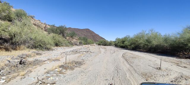
A wadi in Arizona at 32° 49’ 23.448” N, 112° 31’ 29.946” W. Aerial view of the location on Bing Maps here.
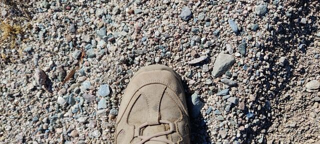
A picture of the sediment in the wadi at the same location. Although the wadi may appear sandy from a distance, the surface is actually a mixture of pebbles, gravel, and cobble.
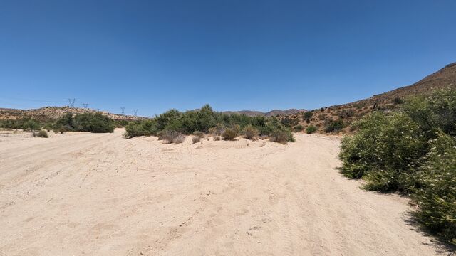
A wadi in California at 32°37’34.7"N 116°09’03.5"W. Aerial view of the location on Bing Maps here.
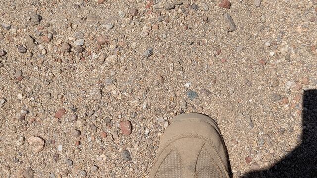
A picture of the sediment in the wadi at the same location. The surface is a mixture of pebbles and gravel.
For an aerial view of wadis, consider imagery from Bing of wadis along Lake Mohave at 35.385102, -114.645299. If you zoom in, the pronounced (i.e., verifiable) banks of the wadi and the shifting (i.e., not permanent) lines of the water courses of successive floods are visible. Darker sediments in these wadis have accumulated desert varnish as they have been undisturbed (i.e., dry) for hundreds or thousands of years.
Existing examples of natural=wadi in OSM:
Rendering
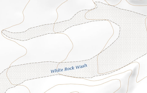
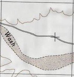
The suggested rendering is as a tan area with light brown dots and a dashed border of light brown or blue. This would be similar to the current OSM Carto rendering for natural=scree or natural=shingle but with the addition of a dashed border to identify the banks on either side.
The rendering should be distinct from natural=sand and natural=bare_rock as a wadi may be bounded by areas of sand or bare rock.
Current rendering in the USGS National Map:
Previous rendering of a wide wash in USGS topographic maps:
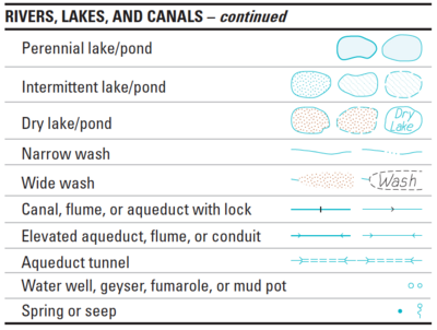
The rendering for a mainly dry watercourse in Geoscience Australia topographic maps is similar.
Features/Pages affected
The Tag:natural=wadi page will be created with the approved details from this proposal.
The Tag:waterway=wadi page will be edited to refer to the Tag:natural=wadi page to map the broad areas of dry watercourses. The existing guidance that waterway=wadi is deprecated will remain.
The Wadi page that currently redirects to Tag:waterway=wadi will be changed to redirect to Tag:natural=wadi.
Links to Tag:natural=wadi will be added to the "See also" sections of Waterways, Key:waterway, and Key:intermittent.
External discussions
This proposal is the result of an extensive discussion about mapping wadis in the OSM Community Forum.
Comments
Please comment on the discussion page.
