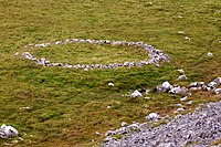
Tag:archaeological_site=enclosure
| Description |
|---|
| An enclosure in the archaeological sense is a historical space separated from its surroundings by a man made barrier. |
| Group: historic |
| Used on these elements |
| Requires |
| Status: in use |
| Tools for this tag |
|
An enclosure as an archaeological_site=* is a piece of land separated from its surroundings by a ditch, earthworks, palisade, wall or combination of those. They occur globally and can stem from a number of eras (historic:period=*) and civilizations (historic:civilization=*).
Mapping
On satellite imagery, enclosures can be recognized from crop marks (be careful not to confuse tractor marks with crop marks - compare satellite imagery!) or an enclosure formed by vegetation like scrubs or trees. Without further knowledge of the location, it is better to classify what you see as an enclosure[1] than to presume it to be something more specific like a henge, fortification_type=ringfort or graveyard. Later contributors might be able to "upgrade" the enclosure to something more specific.
When you have checked available sources for your area/ country and the location is not a recognized archaeological site, it might be worth contacting your local heritage authorities and report it to them.
References
- ↑ That is how the National Monuments Service in Ireland does it anyway.
