Tag:natural=tundra
 |
| Description |
|---|
| Treeless cold climate habitat with open, low growing sedges, grasses, mosses and lichens. |
| Group: natural |
| Used on these elements |
| Useful combination |
| See also |
| Status: in use |
| Tools for this tag |
|
Treeless habitat, characterised by open, low growing vegetation with sedges, grasses, mosses and lichens.
In physical geography, a tundra is a region where the tree growth is hindered by low temperatures and short growing seasons. There are three types of tundra: arctic tundra, alpine tundra and antarctic tundra. In a tundra, the vegetation is composed of dwarf shrubs, sedges and grasses, mosses, and lichens.
Alpine tundra occurs in mountains worldwide. The flora of the alpine tundra is characterized by perennial grasses, sedges, forbs and dwarf shrubs close to the ground. The cold climate of the alpine tundra is caused by the low air pressure, and is similar to polar climate. The boundary between the tundra and the forest is known as the tree line.
Should only be used for areas with actual tundra vegetation, not for large scale tagging of areas with a climate where tundra occurs. Neither should it be used for areas treeless only due to human activities.
For areas lacking vegetation due to cold climate use natural=sand, natural=scree, natural=shingle or natural=bare_rock.
Consider specifically mapping individual areas of vegetation with more common and specific tags:
- natural=heath areas of dwarf shrubs
- natural=scrub areas of shrubs and bushes
- natural=grassland areas covered by grasses and sedges
- natural=wetland + *wetland=bog for areas of bog or fen covered by mosses
- natural=wetland + *wetland=marsh for areas of marsh
Meaning of this tag overlaps with the more common tag natural=fell.
See also
- Vegetation
- natural=wood
- natural=scrub
- natural=grassland
- natural=heath
- natural=fell
- natural=wetland + *wetland=bog
Examples

Alpine tundra in the Ural.

Alpine tundra in Colorado

Alpine tundra in the Alps

Tundra in Greenland

Tundra in Siberia

Tundra on the Péninsule Rallier du Baty, Kerguelen Islands.

Tundra region with fjords, glaciers and mountains. Kongsfjorden, Spitsbergen.

IslaBridges in the Beagle Channel, Argentia

Sarek National Parc, Sveden
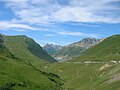
Croix de Fer, France


| ||||||||||||||||||||||||||||||||