Tag:tower:type=diving
Jump to navigation
Jump to search
 |
| Description |
|---|
| Diving tower. |
| Group: man made |
| Used on these elements |
| Requires |
| Useful combination |
| Status: in use |
| Tools for this tag |
|
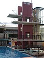
A diving tower is a construction to jump off into a sufficiently deep water surface, usually in outdoor or indoor swimming pools. The competition heights are 1 meter and 3 meters from a diving board in artificial diving, and 5, 7.5 and 10 meters from a platform in high diving.
How to map
Set a node ![]() or draw as an area
or draw as an area ![]() along the outline and tag it with:
along the outline and tag it with:
If the the height is known add height=* and the number of diving platforms platforms=*.
Tag used in combination
- height=* - height in meters
- platforms=number - the tower has number platforms
- indoor=* - the tower is located indoor (e.g. in a sport center)
- tower:construction=* - the kind of construction: freestanding or lattice
- material=concrete - the main construction material, concrete, wood, stone, steel, iron
- lit=yes - the tower is lit
- access=customers - the access possibilities
- opening_hours=* - the opening hours
Rendering
Röntgen icons
| Tag | Icon |
|---|---|
| platforms=1 | |
| platforms=2 | |
| platforms=3 | |
| platforms=4 |
Examples of diving towers

diving tower im Hvalstrand Bad
diving center in Maas

diving center in Eindhoven

diving tower im "Freibad Brauweg Göttingen"


