United States/Trail Access Project
The US Trail Access Project is a community effort to ensure responsible mapping of trails on recreational lands in the United States. This project is a collaboration between the OpenStreetMap US mapping community and land management agencies of the US Government. This wiki page is a project plan intended to address the issues surrounding responsible mapping of public recreation and heritage sites. Interested in joining the conversation? See Trails Working group.
The scope of this project is US public access lands administered by the US Government. However, the principles in this project plan may be applicable to other public lands at the state and local level.
Background
On September 22, 2021 Keri Nelson, a backcountry coordinator for the US Park Service presented a "Mappy Hour" presentation titled "Trails in OpenStreetMap". The presentation described the damages that have resulted from visitors hiking through backcountry areas and sensitive sites outside of designated hiking trails. Backcountry enthusiasts have used maps and apps sourced from OpenStreetMap data to find and navigate trails in US national parks and public lands that are not designated as part of the park's managed trail system and not listed on official maps.
Park Service representatives cited the following issues:
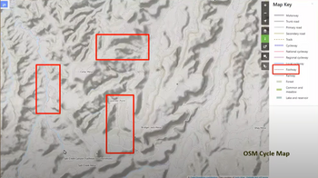
1. Closed/unmarked trails rendering the same as or more strongly than official/managed trails: On several OSM-based maps and/or hiking apps, examples were cited in which closed, illegal, or non-existing trails were rendered exactly the same as, or more prominently than the marked trail system managed by the park service. This created an expectation amongst park visitors that these trails were of a similar access and character to other trails in the park.
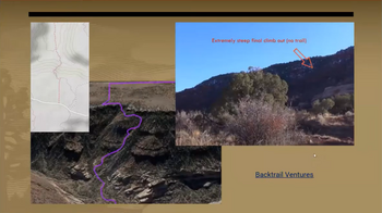
2. Trails marked in locations where there is no trail: In some cases, trails were marked in locations where there was no trail physically on the ground. In the photo below, a route terminates at a steep canyon wall; a mapper had marked a trail up the canyon wall face where no trail exists.
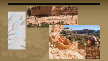
3. Social trails mapped to posted dangerous areas or off-limits sensitive sites with illegal access Of particular concern to the Park Service are that hikers have created "social trails" to sensitive sites and mapped these on OpenStreetMap. This has encouraged other hikers to follow these trails, causing damage to the important locations.
Nomenclature
This project uses the following terminology:
- Official Trail - A trail which physically manifests on the ground and is marked, blazed, or signed by the land owner/manager. In cases where the the trail passes over wear-resistant surfaces such as bare rock, the trail may be manifested only by markings such as cairns, paint blazes, or signs. Official trails are normally marked in trail maps published by the land owner/manager.
- Social Trail - An unmarked but physically manifested path created by repeated use by pedestrians or hikers as a shortcut or in order to access a location away from another trail.
- Closed Trail - A trail which physically exists, but access to the trail is permanently prohibited by the land manager/owner and marked or signed as closed. These trails might be used, for example, for land access by land managers but not open to the general public. This does not include trails that may be temporarily or seasonally closed.
- Way - A line drawn in OpenStreetMap that is used to represent a trail or path.
Analysis
- OpenStreetMap is an open database of geospatial information. In order for park trails to render in the desired way, they must be accurately tagged so that renderers can decide which trails to show, which trails to not show, and which trails to emphasize or de-emphasize. Marking trails a certain way in OpenStreetMap should not be seen as an alternative to physically marking trail access rules on the ground.
- Neither the community of mappers, nor the United States chapter of OpenStreetMap (OSM US), nor the global OpenStreetMap Foundation (OSMF) control the decisions made by the authors of various maps and applications. Even if trails are appropriately tagged, it may still be required to work with the individual developers of these products to achieve the desired user-facing outcomes.
- Even with good data, and good rendering, each application sets its own frequency for how often the map is updated. Applications may take days, weeks, or months to update after a change is made to the map.
Plan of action
Proposed is the following plan of action:
| Phase | Actions Taken | Roles |
|---|---|---|
| 1. Establish tagging standards |
|
|
| 2. Execute nationwide park trail tagging campaign |
|
|
| 3. Continuous monitoring of trail renderers |
|
|
Recommendations to land managers
Regulating traffic is one of the main Land Manager's methods to ensure safety of visitors, environment protection or owner's privacy. In reality this task can only be achieved in full coordination with all involved parties. In ideal case, 1) Land Managers ensure appropriate physical marking of trails and provide information about access restrictions. This in turn serves as information for 2) OSM members for correct tagging of the digital paths. These data are then used by 3) App developers to inform app users about accessibility of certain areas or provide routing that avoids restricted trails. Land mangers can afterwards evaluate visitors behavior and adjust the restrictive marking and devices, which triggers another round of this cyclic process.
In addition it is important to keep in mind that every individual visitor of the property is obligated to follow posted rules and restriction regardless of what the routing device or map might suggest. Experience shows that the vast majority of visitors care about nature conservation and owner's privacy and try to avoid breaking the set rules. If they are found trespassing it is often due to missing restrictive signs or accidentally not noticing the posted warnings. Therefore taking proactive measures in form of posted information can avoid vast majority of trespassing accidents.
Here are some of the possible ways how to inform visitors about trails and areas accessibility:
- Place no trespassing signs at the beginning of the closed or restricted social trail, or at the typical place where most visitors are expected to join such trail. Follow the rules or laws in your country/stare or jurisdiction about the correct appearance of the signs. (TODO: example of sign
- Post clear and simple rules at the entrance to the property such as parking lot that clearly state the rules for visitors. This could for example be a restriction to move only on the marked trail. (TODO: picture of information board at park entrance)
- Stretch do not cross tape or string around small areas that are undergoing nature restoration. In addition you can place an information text about the restoration process itself as visitors are more likely to follow rules if the know the purpose behind them. (TODO: get picture of marked restoration area)
- Build a set of marked trails as these serve as a clear guidance for the visitors and prevent off trail movement. Marking can have many forms such as painted blazes, tied ribbons, wooden poles, cairns, etc. (TODO: examples of trail marks)
- Provide map printouts for visitors. Providing small map printouts with trail clearly marked trails/areas that are accessible or restricted can prevent people from relying on apps containing inaccurately presented data.
- Post danger warnings signs before entrances to trails that are too difficult for average visitor or require a special gear. Such warnings along with pictures of the dangerous elements waiting ahead can deter many inexperienced hikers. (TODO: picture?)
Suggested Tagging
| Situation | Tagging |
|---|---|
| An official trail |
|
| A closed trail |
For temporary closures: For trails that are permanently decommissioned, consider adding a lifecycle prefix to the highway=* key, such as closed:highway=path or abandoned:highway=path depending on the situation. |
| A social trail, and access to this social trail, or social trails in general, is prohibited by the land owner/manager.
(as evidenced by posted signs or markings, or by text on e.g. the official website or visitor maps) |
|
| A social trail, and access to this social trail is not prohibited outright, but is officially discouraged by the land owner/manager.
(as evidenced by posted signs or markings, or by text on e.g. the official website or visitor maps) |
|
| A social trail, and access to social trails is not prohibited or discouraged by the land owner/manager | |
| A trail leaving public land for private property where the landowner does not allow access by the general public. | |
| There is no trail at this location, but mappers have marked a way via a "bushwhack" and it is unlikely that another mapper would mark a trail here. |
|
| There is no trail at this location, however, future mappers might mark a trail here due to factors of topography, geography, or the Strava heatmap. |
|
OverpassTurbo-Query to display official (green), informal (yellow), discourage informal (orange), forbidden informal (red) and private (grey) paths.
Additional tags to consider
| Characteristic | Tagging |
|---|---|
| Trail Visibility: How easy it is for an average person to locate and follow such trail. Trails with low visibility are more likely to be social trails, cause visitor to either get lost or enter areas with restricted access. It is therefore important distinguish them from official trails. | |
| Trail Difficulty: How demanding it is for and average person to move along the trail. Trails with steep slope, unstable surface or obstacles are more likely to cause serious accidents. Marking trail difficulty helps to better distinguish paths for visitors with different levels of experience. | |
| "Stages of decay" lifecycle prefixes: Useful for indicating that a trail has fallen into has become overgrown, fallen into disrepair, or been removed. These prefixes can generally be applied to any class of trail (for example, a heavily overgrown trail could be tagged disused:highway=path, regardless of whether it is official or informal and whether access to that trail is allowed). See Lifecycle prefix for a complete list of available prefixes. |
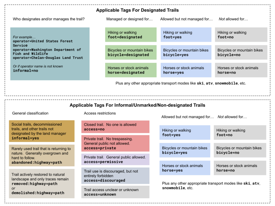
Trail Tagging Chart
Suggested rendering and recommendations to data consumers
How trail information gets rendered by apps has a large influence on users when visiting natural areas. Indiscriminate rendering of all trails can cause risk of conflicts with private owners when moving on land that not intended for public use, damage to protected environment and cultural heritage, or serious injury. To limit such risks, we can adjust how is OSM data is represented on a map or inside a routing algorithm.
In the ideal case, the most prominent path features on a map are Official Trails, which can be identified by the Way representing the trail having a type=route + route=hiking relation or not containing access=private;no or informal=yes tags.
Closed trails, Social trails or Private trails are best not shown at all. However, sometimes showing such trails can help orientation in terrain or help in emergency situations. In such cases, rendering of these trails should be substantially less prominent or clearly marked as inaccessible, e.g. with X marks or displaying text PRIVATE/CLOSED.
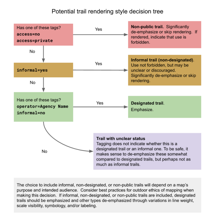
Below is an example of a rendering decision tree distinguishing between designated official trails, unmarked/unofficial trails, social trails, and non-public/closed trails. Map makers will make varying choices about how exactly to render these trail types depending on the purpose of their map. For some purposes displaying only designated official trails may be best. For others, including all types may be appropriate. Ideally designated official trails should always be most prominent, with other types displayed less prominently if included.
See also
- Hiking
- Trail markings
- Proposed features/Social path
- Past community discussions:
- US National Park Service Tagging: Trails
- Australia/Walking Tracks
