User:Deo Favente
Jump to navigation
Jump to search
|
| ||||||||||||||||
User Boxes
Yes, all of these are from wikipedia because I was too lazy to make my own.
| js | This user can program in JavaScript. |
|---|
My area
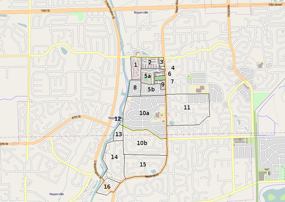
TODO List
P(re)-script: I can't remember some of the subdivision names, and I'm too lazy to check. I'll remember to check when i pass by it some time later (eventually).
- 1 - Olive Trees
- Parking
- POI Amenities
- 2 - Name slips my mind
- Parking
- 3 - Unincorporated
- Zone
- 4 - Some group of houses idk... Done
- 5a - Orleans (North) Done
- 5b - Orleans (South - it may be called 'New Orleans') Done
- 6 - Briar Ridge Done
- 7 - Unincorporated Done
- 8 - Cambridge Cove Done
- 9 - La Toscana Done
- 10a - Naper Carriage Hill (North) - OMG I LIVE HERE
- Put 'recreation' area over the pool and tennis club place.
- 10b - Naper Carriage Hill (South)
- Maybe add more nodes to streets to make the smoother
- Zone residential
- Zone park
- 11 - Hunters Woods NOT STARTED
- 12 - Unincorporated
- Zone residential
- 13 - Scott's Crossing
- Adjust end of streets
- Zone residential
- 14a - River Woods (North) (i fogot to add 'a' in the picture)
- Note - that path in the park is in fact correct, the people in charge of the subdivision cut off the last part of the path, which was on their land and used it for something else. The rest of the path and the park belongs to the city. It's a shame - it was more enjoyable when there were four entrances and you could bike along that path instead of the road. Now you must use the middle entrance and it seems like you're going out of your way.
- Also note - River Woods south isn't on my current agenda. It has -another- school.
- Adjust end of streets
- Zone residential
- Zone park
- 15 - Heritage Knolls
- Re-work roads
- Combine streets
- Adjust end of roads
- Check for dupes / non-connections in roads
- Zone residential
- Fix pond
- Add path
- Zone park
- 16 - DOH NOT STARTED
